Socastee, South Carolina | |
|---|---|
 Socastee Swing Bridge | |
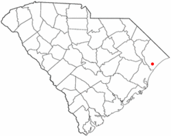
 Location of Socastee in South Carolina | |
| Coordinates: 33°41′N 79°0′W / 33.683°N 79.000°W | |
| Country | United States |
| State | South Carolina |
| County | Horry |
| Area | |
| • Total | 13.88 sq mi (35.96 km2) |
| • Land | 13.37 sq mi (34.62 km2) |
| • Water | 0.52 sq mi (1.34 km2) |
| Elevation | 16 ft (5 m) |
| Population | |
| • Total | 22,213 |
| • Density | 1,661.90/sq mi (641.64/km2) |
| Time zone | UTC−5 (EST) |
| • Summer (DST) | UTC−4 (EDT) |
| ZIP Code | 29588 |
| FIPS code | 45-67390[3] |
| GNIS feature ID | 1226740[4] |
Socastee is a census-designated place (CDP) in Horry County, South Carolina, United States. The population was 19,952 at the 2010 census.
- ^ "ArcGIS REST Services Directory". United States Census Bureau. Retrieved October 15, 2022.
- ^ "Census Population API". United States Census Bureau. Retrieved October 15, 2022.
- ^ "U.S. Census website". United States Census Bureau. Retrieved January 31, 2008.
- ^ "US Board on Geographic Names". United States Geological Survey. October 25, 2007. Retrieved January 31, 2008.