Soddy-Daisy, Tennessee | |
|---|---|
 Soddy-Daisy City Hall | |
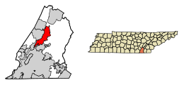
 Location of Soddy-Daisy in Hamilton County, Tennessee | |
| Coordinates: 35°15′31″N 85°10′37″W / 35.25861°N 85.17694°W | |
| Country | United States |
| State | Tennessee |
| County | Hamilton |
| Incorporated | 1969 |
| Area | |
| • Total | 24.04 sq mi (62.26 km2) |
| • Land | 23.18 sq mi (60.02 km2) |
| • Water | 0.86 sq mi (2.24 km2) |
| Elevation | 699 ft (213 m) |
| Population | |
| • Total | 13,070 |
| • Density | 563.97/sq mi (217.75/km2) |
| Time zone | UTC-5 (Eastern (EST)) |
| • Summer (DST) | UTC-4 (EDT) |
| ZIP codes | 37379, 37384 |
| Area code | 423 |
| FIPS code | 47-69560[4] |
| GNIS feature ID | 1270798[2] |
| Website | www |
Soddy-Daisy is a city in Hamilton County, Tennessee, United States. The population was 13,070 at the 2020 census[5] and estimated to be 13,619 in 2022.[6] The city was formed in 1969 when the communities of Soddy (to the north) and Daisy (to the south), along with nearby developed areas along U.S. Route 27, merged to form Soddy-Daisy. It is becoming a bedroom community of nearby Chattanooga and is part of the Chattanooga Metropolitan Statistical Area. Sequoyah Nuclear Generating Station is located in Soddy-Daisy.
- ^ "ArcGIS REST Services Directory". United States Census Bureau. Retrieved October 15, 2022.
- ^ a b U.S. Geological Survey Geographic Names Information System: Soddy-Daisy, Tennessee
- ^ Cite error: The named reference
USCensusDecennial2020CenPopScriptOnlywas invoked but never defined (see the help page). - ^ "U.S. Census website". United States Census Bureau. Retrieved January 31, 2008.
- ^ "Geographic Identifiers: 2010 Census Summary File 1 (G001): Soddy-Daisy city, Tennessee". American Factfinder. U.S. Census Bureau. Archived from the original on February 13, 2020. Retrieved January 29, 2018.
- ^ "Population and Housing Unit Estimates". Retrieved May 21, 2020.