This article needs additional citations for verification. (January 2019) |
Sodepur
Sodpur | |
|---|---|
Neighbourhood | |
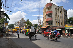
 Amarabati crossing near Sodepur rail overbridge | |
| Coordinates: 22°41′54″N 88°23′22″E / 22.698214°N 88.38947689999998°E | |
| Country | |
| State | West Bengal |
| Division | Presidency |
| District | North 24 Parganas |
| Government | |
| • Type | Municipality |
| • Body | Panihati Municipality |
| Elevation | 15 m (49 ft) |
| Languages | |
| • Official | Bengali, English |
| Time zone | UTC+5:30 (IST) |
| PIN | 700110, 7000113, 700114, 700115, |
| Telephone code | +91 33 |
| Vehicle registration | WB |
| Lok Sabha constituency | Dum Dum |
| Vidhan Sabha constituency | Panihati |
Sodepur (also known as Sodpur) is a neighbourhood in Panihati of North 24 Parganas district in the Indian state of West Bengal. It is a part of the area covered by Kolkata Metropolitan Development Authority (KMDA).[1]
- ^ "Base Map of Kolkata Metropolitan area". Kolkata Metropolitan Development Authority. Archived from the original on 28 September 2007. Retrieved 3 September 2007.

