This article has multiple issues. Please help improve it or discuss these issues on the talk page. (Learn how and when to remove these messages)
|
Solapur district | |
|---|---|
Clockwise from top-left: Vithoba Temple in Pandharpur, Solapur Fort, Ujjani Dam, Grasslands at Nannaj Bustard Sanctuary, Siddeshwar Temple, Solapur | |
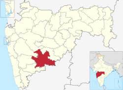
 Location in Maharashtra | |
| Coordinates (Solapur): 17°50′N 75°30′E / 17.833°N 75.500°E | |
| Country | |
| State | Maharashtra |
| Division | Pune Division[1] |
| Headquarters | Solapur |
| Tehsils | 1. Akkalkot, 2. Barshi, 3. Karmala, 4. Madha, 5. Malashiras, 6. Mangalwedha, 7. Mohol, 8. Pandharpur, 9. Sangola, 10. North Solapur and 11. South Solapur |
| Government | |
| • Body | Solapur Zilla Parishad |
| • Guardian Minister | Chandrakant Patil (Cabinet Minister) |
| • MPs | Praniti Sushilkumar Shinde (Solapur) Dhairyasheel Patil (Madha) Omprakash Rajenimbalkar (Dharashiv) |
| Area | |
• Total | 14,895 km2 (5,751 sq mi) |
| Population (2011) | |
• Total | 4,317,756 |
| • Density | 290/km2 (750/sq mi) |
| • Urban | 31.83% |
| Demographics | |
| • Literacy | 71.2% |
| • Sex ratio | 935 |
| Time zone | UTC+05:30 (IST) |
| Vehicle registration | MH13 Solapur MH45 Akluj (Solapur Rural) |
| Website | http://solapur.gov.in/ |
Solapur district (Marathi pronunciation: [solaːpuːɾ]) is a district in Maharashtra state of India. The city of Solapur is the district headquarters. It is located on the south east edge of the state and lies entirely in the Bhima and Seena basins.[2] The entire district is drained by the Bhima River.[3]
Solapur district leads Maharashtra in production of Indian cigarettes known as beedi.[4]
- ^ Sushant Kulkarni (3 July 2015). "Anti-Corruption Bureau: Pune Unit records highest number of bribery traps in state". The Indian Express. Pune. Retrieved 28 July 2015.
- ^ Shri Mahadev Dada Tonpe, Mahavir Shah. "सोलापूर जिल्हा" [Solapur Jilha]. Solapur Pune Pravasi Sanghatna (in Marathi). Solapur. Retrieved 28 July 2015.
- ^ "Solapur District Geographical Information". Archived from the original on 23 February 2007. Retrieved 11 December 2006.
- ^ Meena Menon (21 June 2006). "A dream come true for beedi workers of Solapur". The Hindu. Mumbai. Retrieved 28 July 2015.


