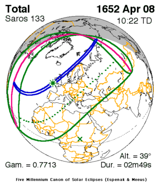
| Solar eclipse of April 8, 1652 | |
|---|---|
| Type of eclipse | |
| Nature | Total |
| Gamma | 0.7713 |
| Magnitude | 1.0412 |
| Maximum eclipse | |
| Duration | 169 s (2 min 49 s) |
| Coordinates | 49°36′N 8°54′W / 49.6°N 8.9°W |
| Max. width of band | 213 km (132 mi) |
| Times (UTC) | |
| Greatest eclipse | 10:22:28 |
| References | |
| Saros | 133 (25 of 72) |
| Catalog # (SE5000) | 8666 |
A total solar eclipse occurred on April 8 New Style (NS), 1652, a Monday. In contemporary British sources, the date is alternately listed as March 29, 1652 following the Old Style (OS) as Great Britain had not yet adopted of the Gregorian Calendar by that time.[1][2] 19th century authors further adjusted the date to March 25 NS, 1652.[3] A solar eclipse occurs when the Moon passes between Earth and the Sun, thereby totally or partly obscuring the image of the Sun for a viewer on Earth. A total solar eclipse occurs when the Moon's apparent diameter is larger than the Sun's, blocking all direct sunlight, turning day into darkness. Totality occurs in a narrow path across Earth's surface, with the partial solar eclipse visible over a surrounding region thousands of kilometres wide. The path of totality intersected the British Isles, as well as passing just off the west coast of Norway.
- ^ Thulesius, Olav (1992). Nicholas Culpeper English Physician and Astrologer. New York: St. Martin's Press. p. 125. ISBN 978-0-230-37153-8. Retrieved July 20, 2017.
- ^ Simpson, J.A.; Weiner, E.S.C. (1989). The Oxford English Dictionary. Oxford: Clarendon Press. p. 111. ISBN 0198612222.
- ^ Barrington, D. (June 1818). "The Possibility of approaching the North Pole Asserted". The Edinburgh Review. 30 (59): 29.
