| Solar eclipse of June 16, 1806 | |
|---|---|
| Type of eclipse | |
| Nature | Total |
| Gamma | 0.3204 |
| Magnitude | 1.0604 |
| Maximum eclipse | |
| Duration | 295 s (4 min 55 s) |
| Coordinates | 42°12′N 64°36′W / 42.2°N 64.6°W |
| Max. width of band | 210 km (130 mi) |
| Times (UTC) | |
| Greatest eclipse | 16:24:27 |
| References | |
| Saros | 124 (43 of 73) |
| Catalog # (SE5000) | 9056 |
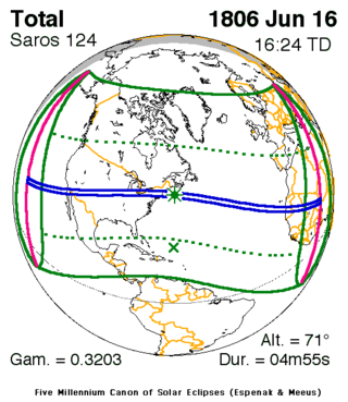
A total solar eclipse occurred at the Moon's descending node of orbit on Monday, June 16, 1806 (sometimes dubbed Tecumseh's Eclipse), with a magnitude of 1.0604. A solar eclipse occurs when the Moon passes between Earth and the Sun, thereby totally or partly obscuring the image of the Sun for a viewer on Earth. A total solar eclipse occurs when the Moon's apparent diameter is larger than the Sun's, blocking all direct sunlight, turning day into darkness. Totality occurs in a narrow path across Earth's surface, with the partial solar eclipse visible over a surrounding region thousands of kilometres wide. Occurring about 1.7 days before perigee (on June 18, 1806, at 9:30 UTC), the Moon's apparent diameter was larger.[1]
The path of totality was visible from parts of modern-day northwestern Mexico, the states of Arizona, New Mexico, Colorado, northwestern Texas, Oklahoma, Kansas, Missouri, southeastern Iowa, Illinois, Indiana, Michigan, Ohio, Pennsylvania, New York, Connecticut, Massachusetts, Vermont, New Hampshire, Rhode Island, and Maine in the United States, Western Sahara, Mauritania, Mali, and Niger. A partial solar eclipse was also visible for parts of North America, Central America, the Caribbean, Europe, and West Africa.
The eclipse was predicted by Shawnee prophet Tenskwatawa and its appearance aided unity among the Indigenous peoples of North America. Astronomer José Joaquín de Ferrer observed and named the solar corona during this eclipse.
- ^ "Moon Distances for London, United Kingdom, England". timeanddate. Retrieved 22 September 2024.
