| Solomon River | |
|---|---|
 Solomon River at Beloit, Kansas | |
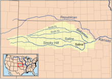
 Map of the Smoky Hill drainage basin including the Solomon River | |
| Location | |
| Country | United States |
| State | Kansas |
| Physical characteristics | |
| Source confluence | Waconda Lake |
| • location | Cawker City, Kansas |
| • coordinates | 39°28′23″N 98°26′00″W / 39.47306°N 98.43333°W |
| • elevation | 1,453 ft (443 m) |
| Mouth | Smoky Hill River |
• location | Solomon, Kansas |
• coordinates | 38°54′13″N 97°22′09″W / 38.90361°N 97.36917°W[2] |
• elevation | 1,142 ft (348 m) |
| Length | 184 mi (296 km) |
| Basin size | 6,835 sq mi (17,700 km2) |
| Discharge | |
| • location | USGS 06876900 at Niles, KS[3] |
| • average | 555 cu ft/s (15.7 m3/s) |
| • minimum | 1 cu ft/s (0.028 m3/s) |
| • maximum | 157,000 cu ft/s (4,400 m3/s) |
| Basin features | |
| Tributaries | |
| • left | North Fork Solomon River |
| • right | South Fork Solomon River |
| Watersheds | Solomon-Smoky Hill-Kansas-Missouri-Mississippi |
The Solomon River, often referred to as the "Solomon Fork", is a 184-mile-long (296 km)[4] river in the central Great Plains of North America. The entire length of the river lies in the U.S. state of Kansas. It is a tributary of the Smoky Hill River.
- ^ "AISRI Dictionary Database Search--prototype version. "River", Southband Pawnee". American Indian Studies Research Institute. Retrieved 2012-05-26.
- ^ a b U.S. Geological Survey Geographic Names Information System: Solomon River
- ^ "Water-Data Report-2012 - 06876900 Solomon River at Niles, KS" (PDF). U.S. Geological Survey. Retrieved 2015-10-20.
- ^ U.S. Geological Survey. National Hydrography Dataset high-resolution flowline data. The National Map, accessed March 29, 2011