Solund Municipality
Solund kommune | |
|---|---|
| Sulen herred (historic name) Utvær herred (historic name) | |
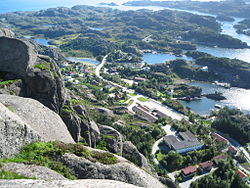
 View of Hardbakke | |
|
| |
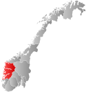
 Vestland within Norway | |
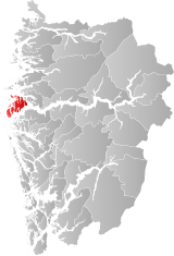
 Solund within Vestland | |
| Coordinates: 61°07′51″N 04°56′52″E / 61.13083°N 4.94778°E | |
| Country | Norway |
| County | Vestland |
| District | Sogn |
| Established | 1858 |
| • Preceded by | Evindvig Municipality |
| Administrative centre | Hardbakke |
| Government | |
| • Mayor (2015) | Gunn Åmdal Mongstad (Sp) |
| Area | |
• Total | 228.2 km2 (88.1 sq mi) |
| • Land | 219.1 km2 (84.6 sq mi) |
| • Water | 9.1 km2 (3.5 sq mi) 4% |
| • Rank | #295 in Norway |
| Population (2023) | |
• Total | 756 |
| • Rank | #345 in Norway |
| • Density | 3.5/km2 (9/sq mi) |
| • Change (10 years) | |
| Demonym | Suling[1] |
| Official language | |
| • Norwegian form | Nynorsk |
| Time zone | UTC+01:00 (CET) |
| • Summer (DST) | UTC+02:00 (CEST) |
| ISO 3166 code | NO-4636[3] |
| Website | Official website |
Solund is a municipality in the county of Vestland, Norway. It is located in the traditional district of Sogn. Solund is the westernmost island municipality in Norway. Holmebåen on the island of Steinsøy is the westernmost point in all of Norway. Most residents of Solund live on the main islands of Sula and Ytre Sula. The administrative centre of Solund is the village of Hardbakke on Sula island. Some other villages in Solund include Kolgrov on Ytre Sula, Hersvikbygda on Sula, and Losnegard on Losna.
The 228-square-kilometre (88 sq mi) municipality is the 295th largest by area out of the 356 municipalities in Norway. Solund is the 345th most populous municipality in Norway with a population of 756. The municipality's population density is 3.5 inhabitants per square kilometre (9.1/sq mi) and its population has decreased by 10.2% over the previous 10-year period.[4][5]
In 2016, the chief of police for Vestlandet formally suggested a reconfiguration of police districts and stations. He proposed that the police station in Solund be closed.[6]
- ^ "Navn på steder og personer: Innbyggjarnamn" (in Norwegian). Språkrådet.
- ^ "Forskrift om målvedtak i kommunar og fylkeskommunar" (in Norwegian). Lovdata.no.
- ^ Bolstad, Erik; Thorsnæs, Geir, eds. (26 January 2023). "Kommunenummer". Store norske leksikon (in Norwegian). Kunnskapsforlaget.
- ^ Statistisk sentralbyrå. "Table: 06913: Population 1 January and population changes during the calendar year (M)" (in Norwegian).
- ^ Statistisk sentralbyrå. "09280: Area of land and fresh water (km²) (M)" (in Norwegian).
- ^ Fjelltveit, Ingvild; Raunholm, Per Vidar (20 December 2016). "Foreslår å legge ned 17 lensmannskontor i Vest politidistrikt". NRK Hordaland (in Norwegian). Retrieved 20 October 2017.

