Solway | |
|---|---|
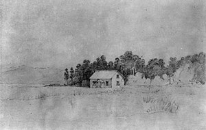
 Donald's homestead at Manaia in front of a corner of Kuripuni Bush, February 1849 William Mein Smith | |
 | |
| Coordinates: 40°57′32″S 175°37′41″E / 40.959°S 175.628°E | |
| Country | New Zealand |
| City | Masterton |
| Local authority | Masterton District Council |
| Area | |
| • Land | 846 ha (2,091 acres) |
| Population (June 2024)[2] | |
• Total | 7,430 |
| Railway stations | Solway railway station |
| Airports | Hood Aerodrome |
| Upper Plain | Ngaumutawa | Kuripuni |
|
|
Masterton East | |
| Carterton |
Solway is an old-established residential suburb near the Waingawa River in the south-western part of Masterton, the principal town in the Wairarapa Valley of New Zealand's North Island. It was a small part of Manaia run on which Masterton is built.[3] It takes its present name from Solway House built in 1877 for W. H. Donald.
Solway College, a Presbyterian girls' boarding school, was established in Solway House in 1916 but Solway's central feature remains the near-moribund Masterton Agricultural & Pastoral Association's Solway Showgrounds[note 1] opened in 1911.[4] A Wairarapa Farmers Market for artisan produce is held under the grandstand each Saturday morning.
Solway also has several parks and reserves, including the Masterton Trust Lands Trust's Millennium Reserve[5] built over the Acclimatisation Society's trout hatcheries and South Park, a softball field and dog-walking area.[6]
- ^ Cite error: The named reference
Areawas invoked but never defined (see the help page). - ^ "Aotearoa Data Explorer". Statistics New Zealand. Retrieved 26 October 2024.
- ^ Early Wairarapa, Story of its Settlement. New Zealand Times 8 July 1922 Page 10
- ^ Heritage New Zealand Solway A & P Showgrounds Historic Area
- ^ Masterton Trust Lands Trust Native Suburban Oasis
- ^ "Parks and Public Spaces". mstn.govt.nz. Masterton District Council.
Cite error: There are <ref group=note> tags on this page, but the references will not show without a {{reflist|group=note}} template (see the help page).