| Solway Basin | |
|---|---|
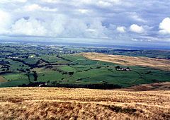
 A view of the Solway Plain from Longlands Fell | |
| Ceremonial county | |
| Country | England |
| Sovereign state | United Kingdom |
The Solway Plain[1] or Solway Basin is a coastal plain located mostly in northwest Cumbria in England, extending just over the Scottish border to the low-lying area around Gretna and Annan.[2] It lies generally north and west of Carlisle along the Solway Firth, and is drained by the rivers Esk and Lyne. It is associated with the westernmost part of Hadrian's Wall.[3] In medieval times, clay houses known as dabbins were commonly built on the Solway Plain.[4] The Solway coast has been designated an “Area of Outstanding Natural Beauty”.[5]
The plain is known for its archaeological heritage. Archaeological finds that are mentioned in Hodgson and Brennand[6] include urned cremation cemeteries at Ewanrigg, evidence suggesting an ancient domestic settlement at Plasketlands, and evidence suggesting pre-Roman occupation at Ewanrigg, Wolsty Hall and Boustead Hill (among other sites). Salta Moss, where a Bronze Age rapier was discovered, boasts flora that is unusual for a mire on the Solway Plain, and has been designated a “Site of Special Scientific Interest” since 1982.[7] As the presence of Hadrian's Wall attests, the Solway Plain is also known for its history as a disputed borderland, control of which was often fought over — from the Roman occupation of Britain to the Border Reivers and Anglo-Scottish conflicts in the Middle Ages.[1]
- ^ a b "Solway Plain National Character Area". Retrieved 17 June 2017.
- ^ A. J. Scott (2015) "Solway Country: Land, Life and Livelihood in the Western Border Region of England and Scotland," Newcastle: Cambridge Scholars Publishing
- ^ "- English Heritage". www.english-heritage.org.uk. Retrieved 17 June 2017.
- ^ Nina Jennings, The Building of the Clay Dabbins of the Solway Plain: Materials and Man-Hours, Vernacular Architecture 33 (2002), 19-27 Archived 2011-10-02 at the Wayback Machine
- ^ DiscoverySquare. "Solway Coast Area of Outstanding Natural Beauty". solwaycoastaonb.org.uk. Retrieved 17 June 2017.
- ^ "North West Region Archaeological Research Framework Prehistoric Resource Assessment" (PDF). Retrieved 17 June 2017.
- ^ "Natural England - Solway Moss SSSI" (PDF). Retrieved 21 December 2014.