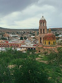
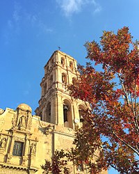
Sombrerete, Zacatecas | |
|---|---|
City and municipality | |
| Sombrerete | |
Sombrerete | |
| Coordinates: 23°38′00″N 103°38′23″W / 23.63333°N 103.63972°W | |
| Country | |
| State | Zacatecas |
| Founded | 1555 |
| Government | |
| • Municipal President | Alan Murillo |
| Elevation (of seat) | 2,500 m (8,200 ft) |
| Population (2010) Municipality | |
• Municipality | 58,201 |
| Time zone | UTC-6 (Central (US Central)) |
| • Summer (DST) | UTC-5 (Central) |
| Postal code (of seat) | 99100 |
| Area code | 433 |
| Website | [1] |
| Official name | Ensamble of the city of Sombrerete |
| Type | Cultural |
| Criteria | ii, iv |
| Designated | 2010 (32nd session) |
| Reference no. | 1351-043 |
| Region | Latin America and the Caribbean |
Sombrerete (Spanish: [sombɾeˈɾete] ) is a town and municipality located in the northwest of the Mexican state of Zacatecas, bordering the state of Durango.
It was founded in 1555 by Spanish conquistador Juan de Tolosa as a mining center, due to the wealth that the mines provided, Sombrerete was one of the most important towns in New Spain. The historical center of Sombrerete, La Noria de San Pantaleón and the Sierra de Órganos National Park were declared in the year 2010 a UNESCO World Heritage Site, adscripted to the Camino Real de Tierra Adentro, Spanish for 'Royal Road of the Interior Land'.
In 2012 it was also declared as a Pueblo Mágico, Spanish for 'magical town' by the Mexican Secretariat of Tourism.


