| Somerleyton | |
|---|---|
 | |
Location within Suffolk | |
| Area | 5.5 km2 (2.1 sq mi) [1] |
| Population | 300 (2011 est.)[2] |
| • Density | 55/km2 (140/sq mi) |
| OS grid reference | TM485974 |
| Civil parish | |
| District | |
| Shire county | |
| Region | |
| Country | England |
| Sovereign state | United Kingdom |
| Post town | Lowestoft |
| Postcode district | NR32 |
| Dialling code | 01502 |
| UK Parliament | |
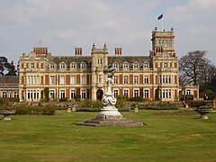
Somerleyton (/ˈsʌmərleɪtən/ SUM-ər-lay-tən) is a village and former civil parish, now in the parish of Somerleyton, Ashby and Herringfleet, in the East Suffolk district, in the north of the English county of Suffolk. It is 4.5 miles (7.2 km) north-west of Lowestoft and 5.5 miles (8.9 km) south-west of Great Yarmouth. The village is closely associated with Somerleyton Hall and was largely rebuilt as a model village in the 19th century at the direction of Samuel Morton Peto. The parish was combined with Herringfleet and Ashby to create the parish of "Somerleyton, Ashby and Herringfleet" on 1 April 1987.[1][3]
The village is on the edge of The Broads national park with the River Waveney forming the western boundary of the former parish. This forms the county border with Norfolk and the Suffolk village of Blundeston is to the east. The village has a population of around 300.[2]
- ^ a b Somerleyton, Suffolk Heritage Explorer, Suffolk County Council. Retrieved 16 March 2021.
- ^ a b Our area, ASH Villages, Somerleyton, Ashby and Herringfleet parish council. Retrieved 16 March 2021.
- ^ The Waveney (Parishes) Order 1987, Local Government Boundary Commission for England. Retrieved 25 January 2020.
