Sonora | |
|---|---|
| Free and Sovereign State of Sonora Estado Libre y Soberano de Sonora (Spanish) | |
 View of San Carlos Nuevo Guaymas | |
| Anthem: Himno del Estatal de Sonora[1] | |
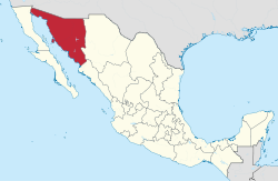
 State of Sonora within Mexico | |
| Coordinates: 29°38′46″N 110°52′08″W / 29.64611°N 110.86889°W | |
| Country | Mexico |
| Capital and largest city | Hermosillo |
| Municipalities | 72 |
| Admission | January 10, 1824[2] |
| Order | 12th[a] |
| Government | |
| • Body | Congress of Sonora |
| • Governor | |
| • Senators[3] | |
| • Deputies[4] | |
| Area | |
• Total | 179,355 km2 (69,249 sq mi) |
| Ranked 2nd | |
| Highest elevation | 2,620 m (8,600 ft) |
| Population (2020)[7] | |
• Total | 2,944,840 |
| • Rank | 18th |
| • Density | 16/km2 (43/sq mi) |
| • Rank | 27th |
| [8] | |
| Demonym | Sonorense |
| GDP | |
| • Total | MXN 1.055 trillion (US$52.5 billion) (2022) |
| • Per capita | (US$17,503) (2022) |
| Time zone | UTC−7 (MST[10]) |
| • Summer (DST) | UTC-7 (No DST) |
| Postal code | 83–85 |
| Area code | |
| ISO 3166 code | MX-SON |
| HDI | |
| Website | www.sonora.gob.mx |
| ^ a. Joined to the federation under the name of Estado de Occidente (Western State) also recognized as Sonora y Sinaloa. | |
Sonora (Spanish pronunciation: [soˈnoɾa] ), officially Estado Libre y Soberano de Sonora (English: Free and Sovereign State of Sonora), is one of the 31 states which, along with Mexico City, comprise the Federal Entities of Mexico. The state is divided into 72 municipalities; the capital (and largest) city of which being Hermosillo (formerly Pitic), located in the center of the state. Other large cities include Ciudad Obregón, Nogales (on the Mexico-United States border), San Luis Río Colorado, and Navojoa.
Sonora is bordered by the states of Chihuahua to the east, Baja California to the northwest and Sinaloa to the south. To the north, it shares the U.S.–Mexico border primarily with the state of Arizona with a small length with New Mexico, and on the west has a significant share of the coastline of the Gulf of California.
Sonora's natural geography is divided into three parts: the Sierra Madre Occidental in the east of the state; plains and rolling hills in the center; and the coast on the Gulf of California. It is primarily arid or semiarid deserts and grasslands, with only the highest elevations having sufficient rainfall to support other types of vegetation.
Sonora is home to eight indigenous peoples, including the Mayo, the O'odham, the Yaqui, and Seri. The state has been economically important for its agriculture, livestock (especially beef), and mining since the colonial period, and for its status as a border state since the Mexican–American War. With the Gadsden Purchase, Sonora lost more than a quarter of its territory. From the 20th century to the present, industry, tourism, and agribusiness have dominated the economy, attracting migration from other parts of Mexico.
- ^ "Canción al Estado de Sonora - "Sonora Querida"". YouTube. 15 April 2016.
- ^ "Las Diputaciones Provinciales" (PDF) (in Spanish). p. 15.
- ^ "Senadores por Sonora LXI Legislatura". Senado de la República. Archived from the original on October 16, 2010. Retrieved October 21, 2010.
- ^ "Listado de Diputados por Grupo Parlamentario del Estado de Sonora". Cámara de Diputados. Archived from the original on July 20, 2018. Retrieved October 20, 2010.
- ^ "Resumen". Cuentame INEGI. Archived from the original on July 23, 2011. Retrieved February 12, 2013.
- ^ "Relieve". Cuentame INEGI. Archived from the original on July 23, 2011. Retrieved October 20, 2010.
- ^ "Encuesta Intercensal 2015" (PDF). Retrieved December 9, 2015.
- ^ Cite error: The named reference
inegi.org.mxwas invoked but never defined (see the help page). - ^ Citibanamex (June 13, 2023). "Indicadores Regionales de Actividad Económica 2023" (PDF) (in Spanish). Retrieved August 13, 2023.
- ^ Miriam de Regil (31 March 2006). "Inicia el domingo el Horario de Verano". El Financiero. Archived from the original on 2011-05-11.
