Sopotnica
Сoпoτница | |
|---|---|
Village | |
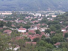
 Panorama of Sopotnica | |
| Coordinates: 41°17′40″N 21°9′18″E / 41.29444°N 21.15500°E | |
| Country | |
| Region | |
| Municipality | |
| Government | |
| • Mayor | Ljupčo Najdovski |
| Area | |
| • Total | 48,013 km2 (18,538 sq mi) |
| Highest elevation | 400 m (1,300 ft) |
| Lowest elevation | 2,000 m (7,000 ft) |
| Population (2002) | |
| • Total | 929 |
| • Density | 19,780/km2 (51,200/sq mi) |
| Time zone | UTC+1 (CET) |
| • Summer (DST) | UTC+2 (CEST) |
| Postal code | 2304 |
| Area code | +389 047 |
| Car plates | DH |
| Website | www.sopotnica.gov.mk/ |
Sopotnica (Macedonian: Сoпoτница) is a village in North Macedonia. It used to be a separate municipality but is now part of the Demir Hisar Municipality.
The area of Sopotnica includes a mix of rural and urban environments. Settled areas range from smaller villages such as Boište, Cerovo and Virovo, located in the mountainous area of Sopotnica, to places with elements of urban living, such as Sopotnica, the administrative centre of the former Municipality of Sopotnica. A key characteristic of the area is the contrast between the wild landscapes and the man-made features of cultivated areas.
The area of Sopotnica is rich in natural resources, and has significant cultural and historical heritage.


