Sotogahama
外ヶ浜町 | |
|---|---|
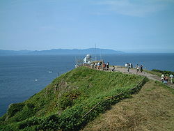
 Cape Tappi, northernmost point of Tsugaru Peninsula | |
 Location of Sotagahama in Aomori Prefecture | |
 | |
| Coordinates: 41°02′35.7″N 140°37′56.4″E / 41.043250°N 140.632333°E | |
| Country | Japan |
| Region | Tōhoku |
| Prefecture | Aomori |
| District | Higashitsugaru |
| Area | |
| • Total | 230.30 km2 (88.92 sq mi) |
| Population (January 1, 2023) | |
| • Total | 4,990 |
| • Density | 22/km2 (56/sq mi) |
| Time zone | UTC+9 (Japan Standard Time) |
| Phone number | 0174-31-1111 |
| Address | Kanita, Takadoya 44-2, Sotogahama-machi, Higashitsugaru-gun, Aomori-ken 030-1393 |
| Website | Official website |
| Symbols | |
| Bird | Common gull |
| Flower | Hydrangea |
| Tree | Japanese black pine |


Sotogahama (外ヶ浜町, Sotogahama-machi) is a town located in Aomori Prefecture, Japan and a part of the Aomori metropolitan area.[1] As of 1 January 2023[update], the town had an estimated population of 4,990 in 2239 households,[2] and a population density of 22 persons per km2. The total area of the town is 230.30 square kilometres (88.92 sq mi).
- ^ "2010 Metropolitan Employment Map". University of Tokyo. Retrieved 6 July 2020.
- ^ "Aoi Mori Open Data Catalog" (in Japanese). Aomori Prefecture. Retrieved 24 February 2023.


