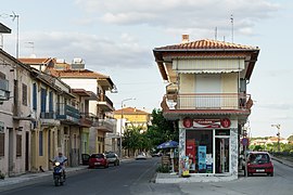
Soufli
Σουφλί | |
|---|---|
 Soufli | |
| Coordinates: 41°12′N 26°18′E / 41.200°N 26.300°E | |
| Country | Greece |
| Geographic region | Thrace |
| Administrative region | Eastern Macedonia and Thrace |
| Regional unit | Evros |
| Area | |
• Municipality | 1,325.7 km2 (511.9 sq mi) |
| • Municipal unit | 462.0 km2 (178.4 sq mi) |
| Elevation | 98 m (322 ft) |
| Population (2021)[1] | |
• Municipality | 11,709 |
| • Density | 8.8/km2 (23/sq mi) |
| • Municipal unit | 5,008 |
| • Municipal unit density | 11/km2 (28/sq mi) |
| • Community | 3,770 |
| Time zone | UTC+2 (EET) |
| • Summer (DST) | UTC+3 (EEST) |
| Postal code | 684 00 |
| Area code(s) | 25540-2 |
| Vehicle registration | EB |
| Website | www.soufli.gr |
Soufli (Greek: Σουφλί, romanized: Souflí) is a town in the Evros regional unit, Greece, notable for the silk industry that flourished there in the 19th century. The town stands on the eastern slope of the twin hill of Prophet Elias, one of the easternmost spurs on the Rhodope Mountains. It is situated in the center of the Evros regional unit, 65 km north of Alexandroupoli and 50 km southwest of Orestiada, on Greek National Road 51/E85 which links Alexandroupoli with Edirne and the Bulgarian border at Ormenio. The town center is only 500m from the Evros River. Soufli is the seat of the municipality of Soufli.
- ^ "Αποτελέσματα Απογραφής Πληθυσμού - Κατοικιών 2021, Μόνιμος Πληθυσμός κατά οικισμό" [Results of the 2021 Population - Housing Census, Permanent population by settlement] (in Greek). Hellenic Statistical Authority. 29 March 2024.

