South Algonquin | |
|---|---|
| Township of South Algonquin | |
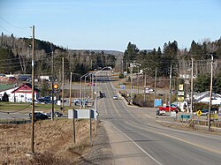
 Highway 60 in Whitney | |
| Coordinates: 45°29′48″N 78°01′26″W / 45.49667°N 78.02389°W[1] | |
| Country | Canada |
| Province | Ontario |
| District | Nipissing |
| Incorporated | October 1961 |
| Government | |
| • Type | Township |
| • Mayor | Ethel LaValley |
| • Governing body | South Algonquin Township Council |
| • Councillors | List |
| • Federal riding | Renfrew—Nipissing—Pembroke |
| • Prov. riding | Renfrew—Nipissing—Pembroke |
| Area | |
• Total | 873.43 km2 (337.23 sq mi) |
| Population (2016)[2] | |
• Total | 1,096 |
| • Density | 1.3/km2 (3/sq mi) |
| Time zone | UTC-5 (EST) |
| • Summer (DST) | UTC-4 (EDT) |
| Postal code | K0J 2M0 |
| Area code(s) | 613, 343 |
| Website | www |
South Algonquin is a township municipality[1] in Nipissing District, Ontario, Canada.[1][3][4][5][6] Located south of Algonquin Provincial Park, it is the sole populated portion of the district that lies south of the traditional dividing line between Northern Ontario and Southern Ontario and is closer connected to Renfrew County as opposed to the core portions of Nipissing District.
The township had a population of 1,096 in the Canada 2016 Census.[2]
- ^ a b c "South Algonquin". Geographical Names Data Base. Natural Resources Canada. Retrieved August 30, 2018.
- ^ a b c Cite error: The named reference
cp2016was invoked but never defined (see the help page). - ^ "Toporama (on-line map and search)". Atlas of Canada. Natural Resources Canada. September 12, 2016. Retrieved August 30, 2018.
- ^ "Ontario Geonames GIS (on-line map and search)". Ontario Ministry of Natural Resources and Forestry. 2014. Retrieved August 30, 2018.
- ^ Map 9 (PDF) (Map). 1 : 1,600,000. Official road map of Ontario. Ministry of Transportation of Ontario. January 1, 2018. Retrieved August 30, 2018.
- ^ Restructured municipalities - Ontario map #5 (Map). Restructuring Maps of Ontario. Ontario Ministry of Municipal Affairs and Housing. 2006. Archived from the original on June 16, 2019. Retrieved August 30, 2018.
