| South Caucasus | |
|---|---|
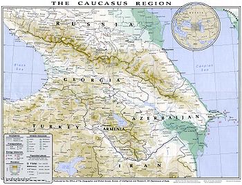
 1994 map of Caucasus region prepared by the U.S. State Department | |
| Coordinates | 42°15′40″N 44°07′16″E / 42.26111°N 44.12111°E |
| Countries | |
| Time Zones | UTC+04:00, UTC+03:30 and UTC+03:00 |
| Highest mountain | Shkhara (5,203 metres (17,070 ft)) |
The South Caucasus, also known as Transcaucasia or the Transcaucasus, is a geographical region on the border of Eastern Europe and West Asia, straddling the southern Caucasus Mountains.[1][2] The South Caucasus roughly corresponds to modern Armenia, Georgia, and Azerbaijan, which are sometimes collectively known as the Caucasian States. The total area of these countries measures about 186,100 square kilometres (71,850 square miles).[3] The South Caucasus and the North Caucasus together comprise the larger Caucasus geographical region that divides Eurasia.
- ^ "Caucasus". The World Factbook. Library of Congress. May 2006. Retrieved 7 July 2009.
- ^ Mulvey, Stephen (16 June 2000). "The Caucasus: Troubled borderland". News. BBC. Retrieved 1 July 2009.
"The Caucasus Mountains form the boundary between West and East, between Europe and Asia..."
- ^ Solomon Ilich Bruk. "Transcaucasia". Encyclopædia Britannica. Retrieved 3 December 2014.