South Cotabato | |
|---|---|
| Other transcription(s) | |
| • Jawi | سلاتن كوتوات |
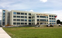
(from top: left to right) Lake Sebu, Seven Falls in Lake Sebu, Mount Matutum, Lake Holon, Another shot of Lake Holon in T'boli and Koronadal City Hall. | |
| Nickname: Land of the Dreamweavers | |
 Location in the Philippines | |
| Coordinates: 6°10′N 125°00′E / 6.17°N 125°E | |
| Country | Philippines |
| Region | Soccsksargen |
| Founded | July 18, 1966 |
| Capital | Koronadal |
| Largest city | General Santos |
| Government | |
| • Type | Sangguniang Panlalawigan |
| • Governor | Reynaldo S. Tamayo Jr. (PFP) |
| • Vice Governor | Arthur Y. Pingoy Jr. (PFP) |
| • Legislature | South Cotabato Provincial Board |
| Area | |
• Total | 3,935.95 km2 (1,519.68 sq mi) |
| • Rank | 32nd out of 81 |
| (excluding General Santos) | |
| Highest elevation | 2,286 m (7,500 ft) |
| Population (2020 census)[2] | |
• Total | 975,476 |
| • Rank | 29th out of 81 |
| • Density | 250/km2 (640/sq mi) |
| • Rank | 41st out of 81 |
| (excluding General Santos) | |
| Divisions | |
| • Independent cities | 1
|
| • Component cities | |
| • Municipalities | |
| • Barangays |
|
| • Districts | |
| Time zone | UTC+8 (PST) |
| ZIP code | 9500–9513 |
| IDD : area code | +63 (0)83 |
| ISO 3166 code | PH-SCO |
| Spoken languages | |
| Income classification | 1st class |
| Website | www |
South Cotabato,[a] officially the Province of South Cotabato, is a province in the Philippines located in the Soccsksargen region in Mindanao. Its capital is Koronadal (also the regional center of Soccsksargen), and it borders Sultan Kudarat to the north and west, Sarangani to the south and northeast, and Davao del Sur to the far northeast. To the southeast lies Sarangani Bay.
General Santos, the only coastal city/town located on the shores of Sarangani Bay, is the largest city in both the province and the region (by population), but is governed independently from the province. The province of Sarangani used to be part of South Cotabato until it was made an independent province in 1992.
- ^ "List of Provinces". PSGC Interactive. Makati City, Philippines: National Statistical Coordination Board. Retrieved May 14, 2014.
- ^ Census of Population (2020). "Region XII (Soccsksargen)". Total Population by Province, City, Municipality and Barangay. Philippine Statistics Authority. Retrieved July 8, 2021.
- ^ "Mapa ng mga Wika (Rehiyon) - Rehiyon XII" (in Filipino). Commission on the Filipino Language. Retrieved September 23, 2021.
Cite error: There are <ref group=lower-alpha> tags or {{efn}} templates on this page, but the references will not show without a {{reflist|group=lower-alpha}} template or {{notelist}} template (see the help page).


