This article needs additional citations for verification. (January 2018) |
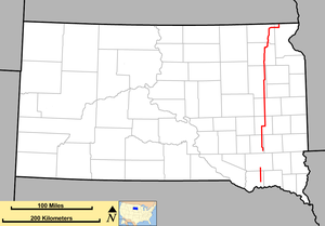
 Map of South Dakota with SD 25 in red | ||||
| Route information | ||||
| Maintained by SDDOT | ||||
| Length | 194.524 mi[1][2] (313.056 km) | |||
| Existed | 1926[citation needed]–present | |||
| Southern segment | ||||
| Length | 19.529 mi[1] (31.429 km) | |||
| South end | ||||
| Major intersections | ||||
| North end | ||||
| Northern segment | ||||
| Length | 174.995 mi[1][2] (281.627 km) | |||
| South end | ||||
| Major intersections | ||||
| North end | ||||
| Location | ||||
| Country | United States | |||
| State | South Dakota | |||
| Counties | Bon Homme, Hutchinson, Hanson, Miner, Kingsbury, Clark, Day, Marshall, Roberts | |||
| Highway system | ||||
| ||||
| ||||
South Dakota Highway 25 (SD 25) is a 194.524-mile-long (313.056 km) state highway in the eastern part of the U.S. state of South Dakota. It connects Scotland, Howard, De Smet, and Webster.
It consists of two disconnected segments. Its shorter southern segment extends 19.529 miles (31.429 km) from SD 50 northwest of Tabor to U.S. Route 18 (US 18) west of Olivet. Its much-longer northern segment extends 174.995 miles (281.627 km) from SD 262 northwest of Emery, through Howard, De Smet, and Webster, to the North Dakota state line. Here, the roadway continues as North Dakota Highway 18 (ND 18).
SD 25's northern segment was established in 1926, with its southern terminus in Howard. From what is now SD 262, the SD 25 designated was applied to the road as construction occurred. Therefore, the northern terminus was at Farmer by 1971, Epiphany by 1977, and the Howard area by 1981. It was shifted west out of Howard in the early 1950s. Its northern path took a zigzag route northward. From De Smet, it went through Clark to Webster. It went west approximately 15 miles (24 km) and headed north to Britton. It then met the North Dakota state line northeast of Kidder. Part of this path is now SD 27. It was then shifted to its current path. In the mid-1970s, it utilized former SD 23 from Webster to Lake City. Between Hammer and the state line, it utilized part of SD 15's former path. The southern segment was the path of former SD 35. It was redesignated in 1976.
- ^ a b c "State Highway Log – Mitchell Region" (PDF). South Dakota Department of Transportation. January 2017. pp. 26–27. Retrieved February 1, 2018.
- ^ a b "State Highway Log – Aberdeen Region" (PDF). South Dakota Department of Transportation. January 2017. pp. 64–68. Retrieved February 1, 2018.
