| South Fork Kern River | |
|---|---|
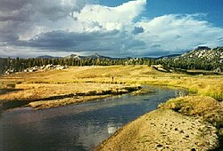
 Headwaters of the South Fork Kern River in Tulare County | |
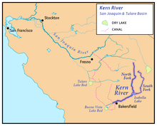
 Map showing the Kern River and the South Fork Kern River (to the east of the main stem) | |
| Location | |
| Country | United States |
| State | California |
| Region | Inyo County, Tulare County, Kern County |
| Cities | Onyx, Weldon |
| Physical characteristics | |
| Source | Southwest side of unnamed peak |
| • location | near Horseshoe Meadow, Inyo National Forest, Tulare County |
| • coordinates | 36°25′55″N 118°12′48″W / 36.43194°N 118.21333°W[1] |
| • elevation | 10,850 ft (3,310 m) |
| Mouth | Lake Isabella |
• location | Mountain Mesa, Kern County |
• coordinates | 35°39′34″N 118°27′51″W / 35.65944°N 118.46417°W |
• elevation | 2,490 ft (760 m)[1] |
| Length | 95 mi (153 km), North-south[2] |
| Basin size | 982 sq mi (2,540 km2)[3] |
| Discharge | |
| • location | Isabella, California[3] |
| • average | 105 cu ft/s (3.0 m3/s)[3] |
| • minimum | 4 cu ft/s (0.11 m3/s)[3] |
| • maximum | 4,100 cu ft/s (120 m3/s)[4] |
| Basin features | |
| River system | Kern River watershed |
| Tributaries | |
| • left | Canebrake Creek |
| • right | Trout Creek (Kern River) |
| Designated | November 24, 1987 |
The South Fork Kern River is a tributary of the Kern River in the Sierra Nevada of the U.S. state of California. It is one of the southernmost rivers on the western slope of the mountains, and drains a high, relatively dry plateau country of 982 square miles (2,540 km2) along the Sierra Crest. The upper South Fork flows through a series of rugged canyons, but it also drains a flat, marshy valley before joining the Kern River at Lake Isabella.
- ^ a b "South Fork Kern River". Geographic Names Information System. United States Geological Survey, United States Department of the Interior. 1981-01-19. Retrieved 2010-10-16.
- ^ Length derived from river mile markings on USGS topo maps. The uppermost labeled mile is 94, and the river extends about a mile beyond that point to the source meadow.
- ^ a b c d "USGS Gage #11190000 on the South Fork Kern River at Isabella (Monthly Streamflow)". National Water Information System. U.S. Geological Survey. 1929–1952. Retrieved 2010-10-16.
- ^ "USGS Gage #11190000 on the South Fork Kern River at Isabella (Peak Streamflow)". National Water Information System. U.S. Geological Survey. 1929–1952. Retrieved 2010-10-16.