| South Fork Trinity River | |
|---|---|
 South Fork Trinity River at the Highway 299 bridge | |
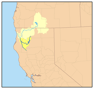
 Map of the Trinity River watershed with the South Fork extending south from the mainstem; watershed highlighted in yellow | |
| Location | |
| Country | United States |
| State | California |
| Region | Klamath Mountains, Humboldt County, Trinity County |
| Physical characteristics | |
| Source | Chicago Spring |
| • location | North Yolla Bolly Mountains, Trinity County |
| • coordinates | 40°09′24″N 122°59′18″W / 40.15667°N 122.98833°W |
| • elevation | 5,921 ft (1,805 m) |
| Mouth | Trinity River |
• location | Salyer, Trinity County |
• coordinates | 40°53′23″N 122°36′08″W / 40.88972°N 122.60222°W |
• elevation | 446 ft (136 m) |
| Length | 92 mi (148 km) |
| Basin size | 980 sq mi (2,500 km2) |
| Discharge | |
| • location | Salyer |
| • average | 1,807 cu ft/s (51.2 m3/s) |
| • minimum | 35 cu ft/s (0.99 m3/s) |
| • maximum | 95,400 cu ft/s (2,700 m3/s) |
| Basin features | |
| Tributaries | |
| • right | East Fork South Fork Trinity River, Hayfork Creek |
| Designated | January 19, 1981 |
The South Fork Trinity River is the main tributary of the Trinity River, in the northern part of the U.S. state of California.[1] It is part of the Klamath River drainage basin. It flows generally northwest from its source in the Klamath Mountains, 92 miles (148 km) through Humboldt and Trinity Counties, to join the Trinity near Salyer. The main tributaries are Hayfork Creek and the East Fork South Fork Trinity River.[2] The river has no major dams or diversions, and is designated Wild and Scenic for its entire length.
One of the largest undammed river systems in California, the South Fork drains a rugged, remote watershed of 980 square miles (2,500 km2). The large areas of intact habitat are important for several endangered species and rare plants. Historically, the South Fork watershed was known for its prodigious anadromous fish population and dense old-growth forests. During the mid-20th century, the river channel was heavily damaged by major flooding, which was exacerbated by erosion caused by mining, logging and ranching. Decades later the South Fork is still considered in the process of recovery.[3]
- ^ "South Fork Trinity River". Geographic Names Information System. United States Geological Survey, United States Department of the Interior. 19 January 1981. Retrieved 2009-07-29.
- ^ "Where and What is the South Fork Trinity River Watershed?" (PDF). South Fork Trinity River Coordinated Resources Management Planning Group. Trinity County Resource Conservation District. Retrieved 2009-07-29.
- ^ "California Rivers: South Fork Trinity River". Friends of the River. www.friendsoftheriver.org. Retrieved 2009-07-29.