This article needs additional citations for verification. (July 2010) |
South Mumbai
South Bombay Old Mumbai / Old Bombay / Mumbai Town / Townside | |
|---|---|
Precinct of Mumbai | |
 View of Marine Drive, one of the richest neighbourhoods of South Mumbai | |
 Island City District highlighted in yellow | |
| Coordinates (Malabar Hill): 18°57′00″N 72°47′42″E / 18.95°N 72.795°E | |
| Country | |
| State | |
| District | |
| City | Mumbai |
| Wards | A, B, C, D, E |
| Government | |
| • Body | BMC |
| Area | |
• Total | 67.7 km2 (26.1 sq mi) |
| Population (2011) | |
• Total | 3,145,966 |
| • Density | 46,000/km2 (120,000/sq mi) |
| Demonym(s) | Mumbaikar, Soboite |
| Time zone | UTC+5:30 (IST) |


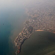
South Mumbai, colloquially SoBo from South Bombay in Indian English,[1][2] administratively the Mumbai City District, is the city centre and the southernmost precinct of Greater Bombay. It extends from Colaba to Mahalaxmi (Western side), Byculla (Central Side) and Mazgaon (Harbour Side) neighbourhoods, and comprises the city's old and formerly main business localities, making it the wealthiest urban precinct in India. Property prices in South Mumbai are by far the highest in India and among the highest in the world. In terms of Maharashtra Legislative Assembly, the precinct consists of the constituencies of Colaba, Mumbadevi, Malabar Hill and Byculla.[3]
Taj Mahal Hotel, Gateway of India, Victoria Terminus, Ballard Estate, and the Bombay Harbour are some of the most iconic landmarks of South Bombay. Billionaire Mukesh Ambani's $1.5 billion home Antilia is located here and is now a part of the iconic skyline. Most residents of South Mumbai belong to old money business, law, trade, and fashion families. Geographically, South Mumbai lies at the southernmost extent of Mumbai Island. Most city residents use the term to refer to the stretch extending from Colaba to Tardeo and Byculla as South Mumbai. The area is delimited on the east by Mumbai harbour and on the west by the Arabian Sea.
South Mumbai is also home to many educational institutions; namely Mumbai University's Fort Campus, Cathedral and John Connon School, St. Anne's High School, Fort, JB Petit, Campion, Bombay International School, Gamdevi, St. Mary's School, Mumbai, etc.; exclusive sports clubs: CCI, The Willingdon Sports Club, as well as the Bombay Gymkhana; and hospitals such as Breach Candy Hospital, Bombay Hospital, Jaslok Hospital, and Hurkisondas Hospital.
- ^ Eyewitness, D. K. (3 October 2019). DK Eyewitness Top 10 Mumbai. Dorling Kindersley Limited. ISBN 978-0-241-43046-0.
- ^ "Malavika's Mumbaistan: Mumbai's North-South Divide". Hindustan Times. 2 July 2021. Retrieved 29 November 2021.
- ^ "Exploring the Charm and Heritage of South Mumbai". 24 May 2024. Retrieved 7 July 2024.


