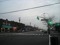
South Ozone Park | |
|---|---|
 | |
 Location within New York City | |
| Coordinates: 40°40′34″N 73°48′43″W / 40.676°N 73.812°W | |
| Country | |
| State | |
| City | |
| County/Borough | |
| Community District | Queens 10[1] |
| Population (2010)[2] | |
• Total | 75,878 |
| Ethnicity | |
| • Black | 25.7% |
| • Asian | 23.3 |
| • Hispanic | 21.0 |
| • Two or more races | 11.0 |
| • Other | 29.0 |
| Economics | |
| • Median income | $73,891 |
| Time zone | UTC−5 (EST) |
| • Summer (DST) | UTC−4 (EDT) |
| ZIP Code | 11420 |
| Area codes | 718, 347, 929, and 917 |
South Ozone Park is a neighborhood in the southwestern section of the New York City borough of Queens. It is just north of John F. Kennedy International Airport, between Aqueduct Racetrack to the west and the Van Wyck Expressway to the east.[4] Adjacent neighborhoods include Ozone Park to the west; Richmond Hill to the north; Jamaica, South Jamaica, and Springfield Gardens to the east; and Howard Beach and Old Howard Beach to the southwest.[4]
Rockaway Boulevard is South Ozone Park's main business strip. There is also a high concentration of small businesses along Liberty Avenue, which is also one of South Ozone Park's main source of revenue.
South Ozone Park is located in Queens Community District 10 and its ZIP Code is 11420.[1] It is patrolled by the New York City Police Department's 106th Precinct.[5] Politically, South Ozone Park is represented by the New York City Council's 28th and 32nd Districts.[6]
- ^ a b "NYC Planning | Community Profiles". communityprofiles.planning.nyc.gov. New York City Department of City Planning. Retrieved April 7, 2018.
- ^ Cite error: The named reference
PLP5was invoked but never defined (see the help page). - ^ Cite error: The named reference
PLP3Awas invoked but never defined (see the help page). - ^ a b "Map of Queens neighborhoods". Archived from the original on August 22, 2008.
- ^ Cite error: The named reference
NYPD 106th Precinctwas invoked but never defined (see the help page). - ^ Current City Council Districts for Queens County, New York City. Accessed May 5, 2017.