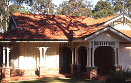
| South Turramurra Sydney, New South Wales | |||||||||||||||
|---|---|---|---|---|---|---|---|---|---|---|---|---|---|---|---|
 Contemporary Federation home, Kissing Point Road | |||||||||||||||
 | |||||||||||||||
| Population | 3,084 (2016 census)[1] | ||||||||||||||
| • Density | 1,028/km2 (2,660/sq mi) | ||||||||||||||
| Established | 1885 | ||||||||||||||
| Postcode(s) | 2074 | ||||||||||||||
| Elevation | 100 m (328 ft) | ||||||||||||||
| Area | 3.0 km2 (1.2 sq mi) | ||||||||||||||
| Location | 18 km (11 mi) north-west of Sydney CBD | ||||||||||||||
| LGA(s) | Ku-ring-gai Council | ||||||||||||||
| State electorate(s) | Wahroonga | ||||||||||||||
| Federal division(s) | Bradfield | ||||||||||||||
| |||||||||||||||

South Turramurra is a suburb on the Upper North Shore of Sydney in the state of New South Wales, Australia 18 kilometres (11 mi) north-west of the Sydney central business district, in the local government area of Ku-ring-gai Council. Turramurra and North Turramurra are separate suburbs.[2]
South Turramurra is a leafy suburb, surrounded by the upper section of the Lane Cove National Park. There are many walking trails, including the Great North Walk and walking trails with access to neighbouring suburbs such as North Epping, Marsfield and West Pymble.
- ^ Australian Bureau of Statistics (31 October 2012). "South Turramurra (State Suburb)". 2011 Census QuickStats. Retrieved 3 September 2017.
- ^ Gregorys Sydney Street Directory, Gregorys Publishing Company, 2007