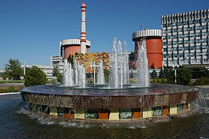
| South Ukraine Nuclear Power Plant | |
|---|---|
 | |
 | |
| Official name | Південноукраїнська АЕС |
| Country | Ukraine |
| Location | Pivdennoukrainsk, Mykolaiv Oblast |
| Coordinates | 47°49′0″N 31°13′0″E / 47.81667°N 31.21667°E |
| Status | Operational |
| Construction began | Unit 1: 1 August 1976 Unit 2: 1 July 1981 Unit 3: 1 November 1984 |
| Commission date | Unit 1: 2 December 1983 Unit 2: 6 April 1985 Unit 3: 29 December 1989 |
| Owner | Energoatom |
| Operator | Energoatom |
| Nuclear power station | |
| Reactor type | PWR |
| Reactor supplier | Atomstroyexport |
| Cooling source | Tashlytske Reservoir |
| Thermal capacity | 3 × 3000 MWth |
| Power generation | |
| Units operational | 3 × 950 MW |
| Make and model | VVER-1000/302 VVER-1000/338 VVER-1000/320 |
| Nameplate capacity | 2850 MW |
| Capacity factor | 65.56% |
| Annual net output | 16,367 GW·h (2016) |
| External links | |
| Website | sunpp.mk.ua[dead link] |
| Commons | Related media on Commons |
The South Ukraine Nuclear Power Plant (Ukrainian: Південноукраїнська АЕС), also known as the Pivdennoukrainsk Nuclear Power Plant, is a nuclear power plant in Ukraine, near the city of Pivdennoukrainsk in Mykolaiv Oblast, about 350 kilometres (220 mi) south of Kyiv. It is the second largest of the country's five nuclear power stations. It is part of the South Ukrainian Energy Complex, along with the Tashlyk Pumped-Storage Power Plant and Oleksandrivska hydroelectric power station.
It has three VVER-1000 pressurized water reactors and a net generation capacity of 2,850 megawatts (MW). In 2013, following major upgrade work, unit 1 was given a 10-year license extension, which will take it beyond its original 30-year design lifetime. Similar extensions are planned for units 2 and 3, licensed until 2015 and 2019, respectively.[1]
The 750 kV Vetrino–Isaccea–Yuzhnoukrainsk powerline runs from the plant to Isaccea, Romania, but is mostly dismantled or ruined.[citation needed]

- ^ "Life extension for South Ukraine unit 1". World Nuclear News. 10 December 2013. Retrieved 12 December 2013.