Southampton, Massachusetts | |
|---|---|
 Woodbridge Hall | |
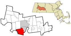
 Location of Southampton in Hampshire County, Massachusetts (left) and of Hampshire County in Massachusetts (right) | |
| Coordinates: 42°13′45″N 72°43′50″W / 42.22917°N 72.73056°W | |
| Country | United States |
| State | Massachusetts |
| County | Hampshire |
| Settled | 1732 |
| Incorporated | April 19, 1775 |
| Government | |
| • Type | Open town meeting |
| Area | |
• Total | 29.1 sq mi (75.3 km2) |
| • Land | 28.2 sq mi (72.9 km2) |
| • Water | 0.9 sq mi (2.4 km2) |
| Elevation | 230 ft (70 m) |
| Population (2020) | |
• Total | 6,224 |
| • Density | 210/sq mi (83/km2) |
| Time zone | UTC−5 (Eastern) |
| • Summer (DST) | UTC−4 (Eastern) |
| ZIP Code | 01073 |
| Area code | 413 |
| FIPS code | 25-62745 |
| GNIS feature ID | 0618207 |
| Website | www.townofsouthampton.org |
Southampton (/saʊθˈhæmptən/ )[1] is a town in Hampshire County, Massachusetts, United States. It was established first as a district of Northampton in 1732. It was incorporated in 1775. The name Southampton was given to it during its first town meeting in 1773. Its ZIP code is 01073. Southampton is part of the Springfield, Massachusetts Metropolitan Statistical Area. The town had a population of 6,224 at the 2020 census.[2]
Southampton was rated having the best tasting tap water in the country in 2008 by the National Rural Water Association.[3]
In 1964, former U.S. Senator Ted Kennedy was involved in a plane crash in the town.[4]
- ^ "Southampton". Dictionary.com Unabridged (Online). n.d. Retrieved November 15, 2014.
- ^ "Census - Geography Profile: Southampton town, Hampshire County, Massachusetts". Retrieved November 14, 2021.
- ^ "Massachusetts town tapped for nation's best water". CNN. April 22, 2008.
- ^ "Plane crash in Southampton in 1964 inspired Ted Kennedy to promote health care for all Americans". August 27, 2009.
