Southbroom | |
|---|---|
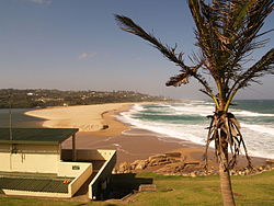
 Southbroom beach | |
| Coordinates: 30°55′12″S 30°19′01″E / 30.920°S 30.317°E | |
| Country | South Africa |
| Province | KwaZulu-Natal |
| District | Ugu |
| Municipality | Ray Nkonyeni |
| Area | |
| • Total | 10.93 km2 (4.22 sq mi) |
| Population (2011)[1] | |
| • Total | 1,615 |
| • Density | 150/km2 (380/sq mi) |
| Racial makeup (2011) | |
| • Black African | 25.6% |
| • Coloured | 0.5% |
| • Indian/Asian | 0.4% |
| • White | 73.1% |
| • Other | 0.4% |
| First languages (2011) | |
| • English | 54.2% |
| • Afrikaans | 24.6% |
| • Zulu | 11.3% |
| • Xhosa | 4.7% |
| • Other | 5.1% |
| Time zone | UTC+2 (SAST) |
| PO box | 4277 |
| Area code | 039 |
Southbroom is a coastal village on the South Coast of the KwaZulu-Natal province of South Africa situated approximately halfway between Port Shepstone – 23 km (14 mi) and Port Edward – 18 km (11 mi).
Southbroom lies approximately 143 km (89 mi) southwest of the coastal city of Durban, and 213 km (132 mi) south of the provincial capital city of Pietermaritzburg.[2] The village was officially founded in 1933,[3] and in the 2011 census had a population of 1,615 in 847 households.
- ^ a b c d "Main Place Southbroom". Census 2011.
- ^ "Google Maps - Location of Southbroom". Retrieved 1 February 2015.
- ^ "Southbroom.org - Dates in time". Retrieved 1 February 2015.

