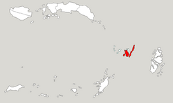
Southeast Maluku Regency
Kabupaten Maluku Tenggara | |
|---|---|
| Motto(s): Larvul Ngabal (The Red-Blooded Spear Originates from Bali) | |
 Location within Maluku | |
| Coordinates: 5°39′17″S 132°44′22″E / 5.6548°S 132.7394°E | |
| Country | Indonesia |
| Province | Maluku |
| Capital | Langgur |
| Government | |
| • Regent | M. Thaher Hanubun |
| • Vice Regent | Petrus Beruatwarin |
| Area | |
• Total | 1,031.01 km2 (398.08 sq mi) |
| Population (mid 2023 estimate)[1] | |
• Total | 129,034 |
| • Density | 130/km2 (320/sq mi) |
| Time zone | UTC+9 (IEST) |
| Area code | (+62) 916 |
| Website | malukutenggarakab |
Southeast Maluku Regency (Indonesian: Kabupaten Maluku Tenggara) is a regency of Maluku, Indonesia. It is coincident with the Kei Islands, except that the city of Tual, although within the Kei Islands geographically and the seat of the Regency's administration, is since 17 July 2007 technically independent of the Regency. The land area of the Regency is 1,031.01 km2, while the sea area administered by the Regency was 3,181 km2; it had a population of 96,442 at the 2010 Census;[2] this increased to 121,511 at the 2020 Census,[3] and the official estimate as at mid 2023 was 129,034.[1]


