Southeastern Massachusetts | |
|---|---|
Region of Massachusetts | |
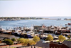
 A view from New Bedford overlooking Buzzards Bay | |
| Country | United States |
| State | Massachusetts |
| Largest city (population) | Brockton (105,643) |
| Largest town (area) | Plymouth (134 square miles) |
| Subregions | Cape Cod and Islands, South Coast, South Shore |
| Area | |
• Total | 4,336.4 sq mi (11,231 km2) |
| • Land | 2,352.3 sq mi (6,092 km2) |
| • Water | 1,983.9 sq mi (5,138 km2) |
| Population | |
• Total | 2,099,851 |
| • Density | 480/sq mi (190/km2) |
Southeastern Massachusetts is a region of Massachusetts located south of Boston and east of Rhode Island. It is commonly used to describe areas with cultural ties to both Boston and Providence, Rhode Island, and includes the cities of New Bedford and Fall River and their respective suburbs. Despite the location of Cape Cod and the islands to its south, which are the southeasternmost parts of the state, they are not often grouped in this designation. At its broadest definition, it includes all of Massachusetts south of Boston, southeast of Worcester, and east of Providence, Rhode Island, while at its narrowest definition, it is Bristol County and the Western portion of Plymouth County. The region including Cape Cod roughly corresponds with the location of the historic Plymouth Colony, which became part of Massachusetts in 1691.