| Southern Downs Region Queensland | |||||||||||||||
|---|---|---|---|---|---|---|---|---|---|---|---|---|---|---|---|
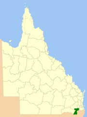
 Location within Queensland | |||||||||||||||
| Population | 36,290 (2021 census)[1] | ||||||||||||||
| • Density | 5.1199/km2 (13.2605/sq mi) | ||||||||||||||
| Established | 2008 | ||||||||||||||
| Area | 7,088 km2 (2,736.7 sq mi) | ||||||||||||||
| Mayor | Melissa Jane Hamilton | ||||||||||||||
| Council seat | Warwick | ||||||||||||||
| Region | Darling Downs | ||||||||||||||
| State electorate(s) | Southern Downs | ||||||||||||||
| Federal division(s) | Maranoa | ||||||||||||||
 | |||||||||||||||
| Website | Southern Downs Region | ||||||||||||||
| |||||||||||||||
The Southern Downs Region is a local government area (LGA) in the Darling Downs region of Queensland, Australia. The region runs along the state's southern boundary with New South Wales and was created in 2008 from a merger of the Shire of Warwick and the Shire of Stanthorpe. As at 2024, it has an area of 7,088 square kilometres (2,737 sq mi).[2]
In the 2021 census, the Southern Downs Region had a population of 36,290 people.[1]
- ^ a b Cite error: The named reference
Census2021was invoked but never defined (see the help page). - ^ "Local government area boundaries - Queensland". Queensland Open Data. Retrieved 29 July 2024.