Southland
Māori: Murihiku | |
|---|---|
| Southland Region | |
 Southland within New Zealand | |
| Country | New Zealand |
| Island | South Island |
| Established |
|
| Seat | Invercargill |
| Territorial authorities | |
| Government | |
| • Body | Southland Regional Council |
| • Chair | Nicol Horrell |
| • Deputy Chair | Lloyd McCallum |
| Area | |
| • Land | 31,218.95 km2 (12,053.70 sq mi) |
| Population (June 2024)[2] | |
| • Region | 106,100 |
| GDP | |
| • Total | NZ$ 7.396 billion (2021) (11th) |
| • Per capita | NZ$ 72,223 (2021) |
| Time zone | UTC+12 (NZST) |
| • Summer (DST) | UTC+13 (NZDT) |
| HDI (2017) | 0.906[4] very high · 10th |
| Website | https://www.es.govt.nz/ |
Southland (Māori: Murihiku, lit. 'the last joint of the tail') is New Zealand's southernmost region. It consists of the southwestern portion of the South Island and includes Stewart Island. Southland is bordered by the culturally similar Otago Region to the north and east, and the West Coast Region in the extreme northwest. The region covers over 3.1 million hectares and spans 3,613 km of coastline. As of June 2023[update], Southland has a population of 103,900, making it the eleventh-most-populous New Zealand region, and the second-most sparsely populated. Approximately half of the region's population lives in Invercargill, Southland's only city.
The earliest inhabitants of Southland were Māori of the Waitaha iwi, followed later by Kāti Māmoe and Kāi Tahu.[5] Early European arrivals were sealers and whalers, and by the 1830s, Kāi Tahu had built a thriving industry supplying whaling vessels, looked after whalers and settlers in need, and had begun to integrate with the settlers.[6] By the second half of the 19th century these industries had declined, and immigrants, predominantly Scottish settlers, had moved further inland.[7] The region maintains a strong cultural identity,[8] including its own distinct dialect of English and strong influences from its Māori and Scottish heritage.[7]
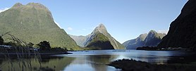
Southland extends from Fiordland in the west past the Mataura River to the Catlins the east. It contains New Zealand's highest waterfall, the Browne Falls, and its deepest lake, Lake Hauroko. Fiordland's terrain is dominated by mountains, fiords and glacial lakes carved up by glaciations during the last ice age, between 75,000 and 15,000 years ago. The region's coast is dotted by several fiords and other sea inlets which stretch from Milford Sound in the north to Preservation Inlet to the south. Farther north and east in Fiordland lie the Darran and Eyre Mountains which are part of the block of schist that extends into neighbouring Central Otago.[9] The region is rich in natural resources, with large reserves of forestry, coal, petroleum and natural gas.
- ^ Cite error: The named reference
Areawas invoked but never defined (see the help page). - ^ "Aotearoa Data Explorer". Statistics New Zealand. Retrieved 26 October 2024.
- ^ "Regional gross domestic product: Year ended March 2022". Statistics New Zealand. 24 March 2023. Retrieved 4 April 2023.
- ^ "Sub-national HDI – Area Database – Global Data Lab". hdi.globaldatalab.org. Retrieved 13 September 2018.
- ^ Grant, David (8 September 2008). "Southland region: Early settlement". Te Ara: The Encyclopedia of New Zealand. Retrieved 22 May 2024.
- ^ Te Rūnanga o Ngāi Tahu. "Ngāi Tahu – the iwi". Retrieved 14 June 2019.
- ^ a b Cite error: The named reference
grant-11-societywas invoked but never defined (see the help page). - ^ Edie, Robyn; Taonga, New Zealand Ministry for Culture and Heritage Te Manatu. "Venture Southland". teara.govt.nz. Retrieved 2 January 2023.
- ^ Cite error: The named reference
grant-2-geowas invoked but never defined (see the help page).


