Sharp ice-free point in the South Shetland Islands, Antarctica
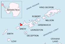
 Location of Byers Peninsula on Livingston Island in the South Shetland Islands
 Eastern Byers Peninsula in Livingston Island with left to right Lair Hill, Robbery Beaches, Sparadok Point, Tsamblak Hill and Negro Hill in the middle ground; and Rowe Point, Cutler Stack, Ivanov Beach, Nedelya Point, Urvich Wall surmounted by the slopes of Rotch Dome, and Clark Nunatak in the background
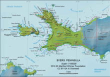
 Topographic map of Byers Peninsula featuring Antarctic Specially Protected Area ASPA 126 and its two restricted zones
 Topographic map of Livingston Island and Smith Island.
Sparadok Point (Bulgarian: нос Спарадок, ‘Nos Sparadok’ \'nos spa-ra-'dok\) is a sharp ice-free point projecting 200 m from the coast of Byers Peninsula on Livingston Island in the South Shetland Islands, Antarctica with a shingle spit extending further 300 m northwards into Barclay Bay. It is surmounted by Tsamblak Hill. The area was visited by early 19th century sealers.
The point is named after the Thracian King Sparadok, 445-435 BC.


