Special Areas Board | |
|---|---|
 Boundary sign | |
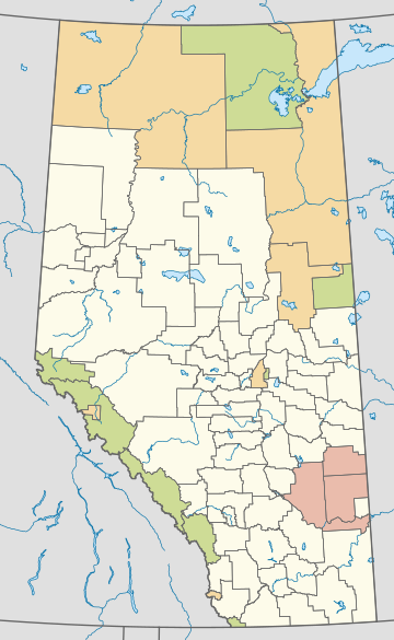
Distribution of Alberta's three special areas | |
| Country | Canada |
| Province | Alberta |
| Regions | Central and Southern Alberta |
| Census division | No. 4 |
| Special Areas Act | 1938 |
| Government | |
| • Governing body | Special Areas Board |
| • Chairperson | Jordon Christianson (acting) |
| • Minister of Municipal Affairs | Ric McIver |
| • District office | Hanna |
| Area (2016)[3] | |
| • Land | 20,375.79 km2 (7,867.14 sq mi) |
| Population (2016)[3] | |
• Total | 4,184 |
| • Density | 0.21/km2 (0.5/sq mi) |
| Time zone | UTC-7 (MST) |
| • Summer (DST) | UTC-6 (MDT) |
| Website | Special Areas Board |
The Special Areas Board is the governing body of Alberta's special areas. Special areas are designated rural municipalities similar to municipal districts; however, the elected advisory councils are overseen by four representatives appointed by the province, under the direct authority of Alberta Municipal Affairs.[4][5]
The three special areas were created in 1938 under the authority of the Special Areas Act[6] as a result of hardship brought upon a particular area in southeastern Alberta during the drought of the 1930s.[4] A special area is not to be confused with a specialized municipality, which is a completely different municipal status.
The special areas are administered under the provisions of the Special Areas Act.[7] The three special areas are located in southeast Alberta within Census Division 4.
- ^ "Municipal Officials Search". Alberta Municipal Affairs. May 9, 2019. Retrieved October 1, 2021.
- ^ "Alberta Municipal Affairs". Alberta Municipal Affairs. Retrieved May 25, 2015.
- ^ a b Cite error: The named reference
2016censusABmunis1was invoked but never defined (see the help page). - ^ a b "Types of Municipalities in Alberta". Alberta Municipal Affairs. May 16, 2008. Retrieved December 18, 2008.
- ^ "About The Special Areas". Special Areas Board. Retrieved December 27, 2009.
- ^ "Special Areas Act". Alberta Queen's Printer. Retrieved December 6, 2009.
- ^ Alberta Queens Printer - Special Areas Act
