Spencerville | |
|---|---|
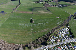
 Spencerville and the Styx River | |
 | |
| Coordinates: 43°25′55″S 172°41′50″E / 43.432042°S 172.697250°E | |
| Country | New Zealand |
| Region | Canterbury |
| Territorial authority | Christchurch City |
| Ward | Coastal |
| Community | Waitai Coastal-Burwood-Linwood |
| Electorates |
|
| Government | |
| • Territorial Authority | Christchurch City Council |
| • Regional council | Environment Canterbury |
| • Mayor of Christchurch | Phil Mauger |
| • Christchurch East MP | Reuben Davidson |
| • Te Tai Tonga MP | Tākuta Ferris |
| Area | |
• Total | 0.37 km2 (0.14 sq mi) |
| Population (June 2024)[1] | |
• Total | 600 |
| • Density | 1,600/km2 (4,200/sq mi) |
Spencerville is a semi-rural town on the east coast of Canterbury, New Zealand north of Christchurch.[2] The town backs on to Bottle Lake Forest and includes a large (1 hectare) park and 80 hectare camping ground.[2] These amenities, as well as wetlands and an animal and bird park make the town a popular camping area for Christchurch residents.[3][4]
After the 2011 Christchurch earthquake, the New Zealand Government classified Spencerville land as Technical Category T3.[5] This requires repairers, builders and developers to meet stricter building standards.[5]
- ^ "Aotearoa Data Explorer". Statistics New Zealand. Retrieved 26 October 2024.
- ^ a b "Community profile – Styx" (PDF). Christchurch City Council. November 2014. Retrieved 19 January 2021.
- ^ "Spencer Park and Brooklands Lagoon" (PDF). Christchurch City Council. 2016. Retrieved 19 January 2021.
- ^ Wright, Michael (5 January 2012). "Holidaymakers brush off quake fears". Stuff. Retrieved 19 January 2021.
- ^ a b Wright, Michael (9 April 2012). "Council turns down red-zone land deal". Stuff. Retrieved 19 January 2021.