| Speyerbach | |
|---|---|
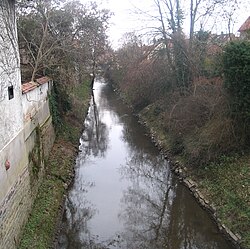
 The Speyerbach in the town of Speyer | |
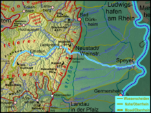
 Course of the Speyerbach to the Rhine through the Palatinate Forest and Rhine valley | |
| Location | |
| Country | Germany |
| State | Rhineland-Palatinate |
| Physical characteristics | |
| Source | |
| • location | near Speyerbrunn |
| • coordinates | 49°20′58.7″N 7°52′13″E / 49.349639°N 7.87028°E |
| • elevation | 296 m (971 ft) |
| Mouth | |
• location | Speyer |
• coordinates | 49°19′9.5″N 8°26′58″E / 49.319306°N 8.44944°E |
• elevation | 92 m (302 ft) |
| Length | 60.1 km (37.3 mi) |
| Basin size | 596 km2 (230 sq mi) |
| Discharge | |
| • average | 3 m3/s (110 cu ft/s) |
| Basin features | |
| Progression | Rhine→ North Sea |
| Tributaries | |
| • left | Breitenbach, Hochspeyerbach, Luhrbach, Woogbach (splits from Speyerbach, changes its name to Nonnenbach, then rejoins) |
| • right | Erlenbach, Helmbach, Mühlbachgraben, Modenbach, Hainbach |
| Cities, towns, and municipalities | Town, Speyer, Lambrecht, Elmstein, Esthal, Frankeneck, Hanhofen, Dudenhofen |


The Speyerbach is a left tributary of the Rhine in the Palatinate part of Rhineland-Palatinate. In Speyer, the river split into Gießhübelbach and Woogbach. The Woogbach changes its name to Nonnenbach, then flows into Gießhübelbach shortly before the latter flows into the Rhine.