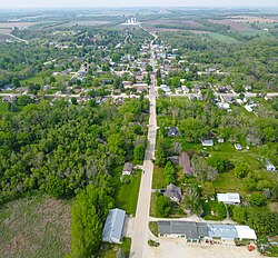
Spillville, Iowa | |
|---|---|
 Turkey River runs through town | |
| Nickname: Spillville Fireworks | |
 Location of Spillville, Iowa | |
| Coordinates: 43°12′N 91°57′W / 43.200°N 91.950°W | |
| Country | |
| State | |
| County | Winneshiek |
| Area | |
| • Total | 0.45 sq mi (1.16 km2) |
| • Land | 0.44 sq mi (1.14 km2) |
| • Water | 0.01 sq mi (0.02 km2) |
| Elevation | 1,070 ft (326 m) |
| Population (2020) | |
| • Total | 385 |
| • Density | 876.99/sq mi (338.41/km2) |
| Time zone | UTC-6 (Central (CST)) |
| • Summer (DST) | UTC-5 (CDT) |
| ZIP code | 52168 |
| Area code | 563 |
| FIPS code | 19-74370 |
| GNIS feature ID | 0461848 |
| Website | www |


Spillville is a city in Winneshiek County, Iowa, United States. The population was 385 at the time of the 2020 census.[2] It is located in Calmar Township, approximately 4 mi (6.4 km) west of Calmar and about 12 miles (19 km) southwest of Decorah, the county seat. Spillville is known for its Independence Day fireworks display, held the first Saturday in July.
- ^ "2020 U.S. Gazetteer Files". United States Census Bureau. Retrieved March 16, 2022.
- ^ "2020 Census State Redistricting Data". census.gov. United states Census Bureau. Retrieved August 12, 2021.