Sprague | |
|---|---|
| Sprague, Washington | |
 | |
 Location of Sprague, Washington | |
| Coordinates: 47°17′56″N 117°58′39″W / 47.29889°N 117.97750°W | |
| Country | United States |
| State | Washington |
| County | Lincoln |
| Area | |
• Total | 1.05 sq mi (2.72 km2) |
| • Land | 1.05 sq mi (2.72 km2) |
| • Water | 0.00 sq mi (0.00 km2) |
| Elevation | 1,903 ft (580 m) |
| Population (2020) | |
• Total | 495 |
| • Density | 470/sq mi (180/km2) |
| Time zone | UTC-8 (Pacific (PST)) |
| • Summer (DST) | UTC-7 (PDT) |
| ZIP code | 99032 |
| Area code | 509 |
| FIPS code | 53-67175[2] |
| GNIS feature ID | 1508614[3] |
| Website | sprague-wa |
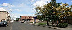
Sprague SPRAYG; is a small city in Lincoln County, Washington, United States. The population was 495 at the 2020 census. The city was platted in 1880 and named for former American Civil War Union general John Wilson Sprague.
- ^ "2019 U.S. Gazetteer Files". United States Census Bureau. Retrieved August 7, 2020.
- ^ "U.S. Census website". United States Census Bureau. Retrieved January 31, 2008.
- ^ "Sprague". Geographic Names Information System. United States Geological Survey, United States Department of the Interior.