Springdale, Utah | |
|---|---|
 | |
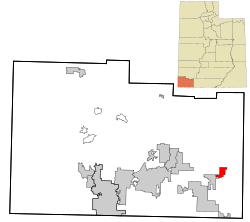
 Location in Washington County and the state of Utah | |
| Coordinates: 37°11′04″N 112°13′00″W / 37.18444°N 112.21667°W | |
| Country | United States |
| State | Utah |
| County | Washington |
| Settled | 1862 |
| Named for | Springs |
| Government | |
| • Mayor | Stanley J. Smith |
| • Council members | Randy Aton, Suzanne Elger, Adrian Player, Lisa Zumpft |
| Area | |
• Total | 4.62 sq mi (11.96 km2) |
| • Land | 4.62 sq mi (11.96 km2) |
| • Water | 0.00 sq mi (0.00 km2) |
| Elevation | 3,855 ft (1,175 m) |
| Population (2010) | |
• Total | 529 |
| • Density | 136.24/sq mi (52.60/km2) |
| Time zone | UTC-7 (Mountain (MST)) |
| • Summer (DST) | UTC-6 (MDT) |
| ZIP codes | 84767, 84779 |
| Area code | 435 |
| FIPS code | 49-71840[3] |
| GNIS feature ID | 2413319[2] |
Springdale is a town in Washington County, Utah, United States. The population was 529 at the 2010 census. It is located adjacent to the boundaries of Zion National Park.[4] It was originally settled as a Mormon farming community in 1862 by evacuees from the flooding of nearby Northrop.[5]
- ^ "2019 U.S. Gazetteer Files". United States Census Bureau. Retrieved August 7, 2020.
- ^ a b U.S. Geological Survey Geographic Names Information System: Springdale, Utah
- ^ "U.S. Census website". United States Census Bureau. Retrieved January 31, 2008.
- ^ Carlisle, Nate (June 12, 2012). "Audit: Small town Utah cops targeted foreign tourists". The Salt Lake Tribune. The Salt Lake Tribune. Retrieved January 11, 2013.
- ^ Webb, R. H.; Blainey, J. B.; Hyndman, D. W. (2002). "Paleoflood Hydrology of the Paria River, Southern Utah and Northern Arizona, USA". In House, P. Kyle (ed.). Ancient floods, modern hazards: principles and applications of paleoflood hydrology. Vol. 1. American Geophysical Union. p. 297.