| Springs Fire | |
|---|---|
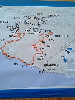
 A map of the footprint of the fire | |
| Date(s) |
|
| Location | Camarillo, California |
| Statistics | |
| Burned area | 24,251 acres (9,814 ha)[1] |
| Impacts | |
| Structures destroyed | 15 |
The Springs Fire was a wildfire in Ventura County, California in May 2013. Although the fire burned only 15 homes,[2] it threatened 4,000. This threat passed when rain shower from few narrow cold-frontal rainbands moved through the California area because of a low-pressure system off the coast. Some places got more than half an inch of rain.[3]
The fire started at 6:45 AM on May 2, 2013, in Camarillo, California near U.S. Route 101 and burned across Pacific Coast Highway to the Pacific Ocean.[4] Several neighborhoods were evacuated, along with the campus of California State University Channel Islands.[5][6]
- ^ "Springs Fire". CAL FIRE. Retrieved August 12, 2015.
- ^ "Rain Helps and Hurts California Wildfire Containment". Huffington Post. May 6, 2013. Retrieved June 9, 2013.
- ^ Lopez, Robert (May 6, 2013). "Storm drops more than half an inch of rain across LA area". Los Angeles Times. Retrieved July 21, 2013.
- ^ "Springs Fire Grows to 28,000 Acres, Only 20% Contained". KTLA. May 3, 2013. Retrieved July 21, 2013.
- ^ Bernstein, Sharon (May 6, 2013). "Firefighters, helped by rain, mop up California wildfire". Reuters. Retrieved July 21, 2013.
- ^ Lopez, Robert J. (May 2, 2013). "California wildfires: Springs fire reaches PCH in Ventura County". Los Angeles Times. Retrieved May 4, 2013.