Kingdom of Sri Ksetra သရေခေတ္တရာ | |||||||
|---|---|---|---|---|---|---|---|
| c. 3rd to 9th century CE–c. 1050s | |||||||
 | |||||||
| Capital | Sri Ksetra | ||||||
| Common languages | Pyu | ||||||
| Religion | Buddhism, Animism, Vaishnavism | ||||||
| Government | Monarchy | ||||||
| Historical era | Classical Antiquity | ||||||
• Founding of Kingdom | c. 3rd to 9th century CE | ||||||
• Launch of Burmese calendar | 21 March 640 | ||||||
• Duttabaung ascends to throne | 25 March 739 | ||||||
• Fall of Kingdom | c. 1050s | ||||||
| |||||||
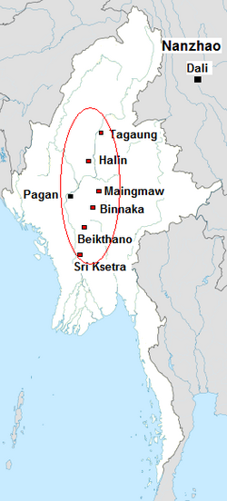
Sri Ksetra (Śrī Kṣetra, Burmese: သရေခေတ္တရာ ပြည်, Burmese pronunciation: [θəjè kʰɪʔtəjà pjì]; Sanskrit: श्री क्षेत्र, lit. 'Field of Fortune'[1] or 'Field of Glory'[2]), located along the Irrawaddy River at present-day Hmawza, was once a prominent Pyu settlement. The Pyu occupied several sites across Upper Myanmar, with Sri Ksetra recorded as the largest, the city wall enclosing an area of 1,477 hectares,[3] although a recent survey found it enclosed 1,857 hectares within its monumental brick walls, with an extramural area of a similar size, being the largest Southeast Asian city before Angkor times.[4] Issues surrounding the dating of this site has meant the majority of material is dated between the seventh and ninth centuries AD, however recent scholarship suggests Pyu culture at Sri Ksetra was active centuries before this.
Sri Ksetra is the site for much of the Pyu artistic legacy. The arrival of Buddhism into the Pyu cities saw the increased artistic production, with very little surviving from the earlier period of occupation. The vast arraying of surviving material indicates a rich visual culture that was endorsed by the Pyu at Sri Ksetra. The Chinese pilgrims Hsuan-tsang in 648 and I-tsing in 675 mentioned the name of Sri Ksetra as “Shh-li-cha‟- t‟o-lo” and that it was a Buddhist country.[5]
The Pyu at Sri Ksetra declined in prominence around the ninth century AD. The final mention of the Pyu is found at Pagan, with a twelfth century stone featuring inscriptions in Pyu, Mon, Burmese and Pali.[6]
- ^ Htin Aung, Maung (1970). Burmese History before 1287: A Defence of the Chronicles. Oxford: The Asoka Society, 8 - 10.
- ^ Aung-Thwin, Michael (1996). "Kingdom of Bagan". In Gillian Cribbs. Myanmar Land of the Spirits. Guernsey: Co & Bear Productions, 77.
- ^ Moore, Elizabeth (2012). The Pyu Landscape: Collected Articles. Myanmar: Department of Archaeology, 175,
- ^ Stargardt, Janice, et al. (2015). "Early urban archaeology in Southeast Asia: the first evidence for a Pyu habitation site at Sri Ksetra, Myanmar", Antiquity Dec 2015, Project Gallery.
- ^ Kyaing, Win, (2019). The Buddhist Cultural Remains of Sri Ksetra, in Asia Pacific Journal of Religions and Cultures Volume 3 No. 2, 2019, p. 51.
- ^ Luce, Gordon H. (1985). Phases of Pre-Pagan: language and history. New York: Oxford University Press, 47.