St. Albert | |
|---|---|
City | |
| City of St. Albert | |
 View of Downtown St. Albert | |
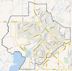
 City boundaries | |
| Coordinates: 53°38′13″N 113°37′13″W / 53.63694°N 113.62028°W[1] | |
| Country | Canada |
| Province | Alberta |
| Region | Edmonton Metropolitan Region |
| Adjacent municipal district | Sturgeon County |
| Founded | 1861 |
| Incorporated[2] | |
| • Village | December 7, 1899 |
| • Town | September 1, 1904 |
| • New town | January 1, 1957 |
| • Town | July 3, 1962 |
| • City | January 1, 1977 |
| Government | |
| • Mayor | Cathy Heron |
| • Governing body |
|
| • CAO | William Fletcher |
| • MP | Michael Cooper (St. Albert—Edmonton-CPC) |
| • MLA | Marie Renaud (St. Albert-NDP) Dale Nally (Morinville-St. Albert-UCP) |
| Area (2021)[4] | |
| • Land | 47.84 km2 (18.47 sq mi) |
| Elevation | 689 m (2,260 ft) |
| Population (2021)[4] | |
• Total | 68,232 |
| • Density | 1,426.4/km2 (3,694/sq mi) |
| • Municipal census (2018) | 66,082[6] |
| • Estimate (2020) | 69,335[7] |
| Time zone | UTC−7 (MST) |
| • Summer (DST) | UTC−6 (MDT) |
| Forward sortation area | |
| Area code(s) | 780, 587, 825, 368 |
| Highways | |
| Waterways | Sturgeon River, Big Lake |
| Website | Official website |
St. Albert is a city in Alberta, Canada, located on the Sturgeon River, northwest of the City of Edmonton, the provincial capital. It was originally settled as a Métis community, and is now the second-largest city in the Edmonton Metropolitan Region. St. Albert first received its town status in 1904 and was reached by the Canadian Northern Railway in 1906.[8] Originally separated from Edmonton by several miles of farmland, the 1980s expansion of Edmonton's city limits placed St. Albert immediately adjacent to the larger city on St. Albert's southern and eastern sides.
- ^ "St. Albert". Geographical Names Data Base. Natural Resources Canada.
- ^ "Location and History Profile: City of St. Albert" (PDF). Alberta Municipal Affairs. June 17, 2016. p. 113. Retrieved June 18, 2016.
- ^ "Municipal Officials Search". Alberta Municipal Affairs. 2019-05-09. Retrieved 2021-10-01.
- ^ a b Cite error: The named reference
2021censuswas invoked but never defined (see the help page). - ^ "Alberta Private Sewage Systems 2009 Standard of Practice Handbook: Appendix A.3 Alberta Design Data (A.3.A. Alberta Climate Design Data by Town)" (PDF) (PDF). Safety Codes Council. January 2012. pp. 212–215 (PDF pages 226–229). Archived from the original (PDF) on September 24, 2015. Retrieved October 9, 2013.
- ^ Cite error: The named reference
2018MAPLwas invoked but never defined (see the help page). - ^ "Census Subdivision (Municipal) Population Estimates, July 1, 2016 to 2020, Alberta". Alberta Municipal Affairs. March 23, 2021. Retrieved October 8, 2021.
- ^ Edmonton Bulletin, September 27, 1906.


