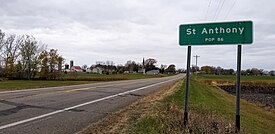
St. Anthony, Minnesota | |
|---|---|
 St. Anthony, Stearns County | |
 Location of the city of St. Anthony within Stearns County, Minnesota | |
| Coordinates: 45°41′20″N 94°36′42″W / 45.68889°N 94.61167°W | |
| Country | United States |
| State | Minnesota |
| County | Stearns |
| Founded | 1880 |
| Incorporated | May 31, 1911 |
| Government | |
| • Mayor | Robert Cremers |
| Area | |
| • Total | 0.493 sq mi (1.276 km2) |
| • Land | 0.493 sq mi (1.276 km2) |
| • Water | 0.000 sq mi (0.000 km2) |
| Elevation | 1,273 ft (388 m) |
| Population | |
| • Total | 91 |
| • Estimate (2022)[4] | 92 |
| • Density | 184.5/sq mi (71.22/km2) |
| Time zone | UTC–6 (Central (CST)) |
| • Summer (DST) | UTC–5 (CDT) |
| ZIP Code | 56307 |
| Area code | 320 |
| FIPS code | 27-56698 |
| GNIS feature ID | 2396472[2] |
| Sales tax | 7.125% |
St. Anthony or Saint Anthony is a city in Stearns County, Minnesota, United States. The population was 91 at the 2020 census.[3] It is part of the St. Cloud Metropolitan Statistical Area. Main routes include Minnesota State Highway 238, Stearns County Road 153, and Trobec Street.
- ^ "2023 U.S. Gazetteer Files". United States Census Bureau. Retrieved February 29, 2024.
- ^ a b U.S. Geological Survey Geographic Names Information System: St. Anthony, Stearns County, Minnesota
- ^ a b "Explore Census Data". United States Census Bureau. Retrieved February 29, 2024.
- ^ Cite error: The named reference
USCensusEst2022was invoked but never defined (see the help page).