St. Charles, Maryland | |
|---|---|
Former CDP | |
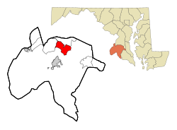
 Location of Saint Charles, Maryland | |
| Coordinates: 38°36′20″N 76°54′57″W / 38.60556°N 76.91583°W | |
| Country | United States |
| State | Maryland |
| County | Charles |
| Area | |
• Total | 11.9 sq mi (30.8 km2) |
| • Land | 11.8 sq mi (30.6 km2) |
| • Water | 0.1 sq mi (0.3 km2) |
| Elevation | 200 ft (61 m) |
| Population (2000) | |
• Total | 33,379 |
| • Density | 2,829.3/sq mi (1,092.4/km2) |
| Time zone | UTC−5 (Eastern (EST)) |
| • Summer (DST) | UTC−4 (EDT) |
| FIPS code | 24-69350 |
| GNIS feature ID | 0591211 |
St. Charles is a planned community in Charles County, Maryland, United States. It is 22 miles (35 km) south-southeast of Washington, D.C., 24 miles (39 km) from northern Virginia and immediately south of Waldorf, which is the mailing address. (St. Charles comprises nearly all the population of Waldorf's zip code 20602, and much of 20603).[citation needed] At the 2000 census, it was delineated as a census-designated place (CDP), with a population of 33,379. It was included in the Waldorf CDP for the 2010 census.