St. Clair County | |
|---|---|
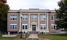
 St. Clair County courthouse in Osceola | |
 Location within the U.S. state of Missouri | |
 Missouri's location within the U.S. | |
| Coordinates: 38°02′N 93°46′W / 38.04°N 93.77°W | |
| Country | |
| State | |
| Founded | January 29, 1841 |
| Named for | Arthur St. Clair |
| Seat | Osceola |
| Largest city | Appleton City |
| Area | |
| • Total | 702 sq mi (1,820 km2) |
| • Land | 670 sq mi (1,700 km2) |
| • Water | 32 sq mi (80 km2) 4.6% |
| Population (2020) | |
| • Total | 9,284 |
| • Density | 13/sq mi (5.1/km2) |
| Time zone | UTC−6 (Central) |
| • Summer (DST) | UTC−5 (CDT) |
| Congressional district | 4th |
| Website | www |
St. Clair County is a county located in the western portion of the U.S. state of Missouri. As of the 2020 census, the population was 9,284.[1] Its county seat is Osceola.[2] The largest city is Appleton City. The county was organized in 1841 and named after General Arthur St. Clair, Governor of the Northwest Territory.[3] St. Clair was also the 9th president of the United States in Congress Assembled. Under his presidency, the Northwest Ordinance and United States Constitution were passed.[4]
According to the April 1907 issue of The Century Magazine, for well over 30 years (dating from 1870) St. Clair County was in open rebellion against the U.S. Government, refusing to pay interest on bonds which it had issued to assist in the building of a railroad, which was never built.
- ^ "Explore Census Data". data.census.gov. Retrieved December 27, 2021.
- ^ "Find a County". National Association of Counties. Retrieved June 7, 2011.
- ^ Eaton, David Wolfe (1918). How Missouri Counties, Towns and Streams Were Named. The State Historical Society of Missouri. pp. 357.
- ^ Klos, Stanley L. (2004). "Arthur St. Clair". President Who? Forgotten Founders. Pittsburgh, Pennsylvania: Evisum, Inc. pp. 367–422. ISBN 0-9752627-5-0.