Saint Helena Parish | |
|---|---|
 | |
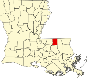
 Location within the U.S. state of Louisiana | |
 Louisiana's location within the U.S. | |
| Coordinates: 30°49′N 90°43′W / 30.82°N 90.71°W | |
| Country | |
| State | |
| Founded | 1810 |
| Named for | Saint Helena |
| Seat | Greensburg |
| Largest town | Greensburg |
| Area | |
| • Total | 409 sq mi (1,060 km2) |
| • Land | 408 sq mi (1,060 km2) |
| • Water | 1.1 sq mi (3 km2) 0.3% |
| Population (2020) | |
| • Total | 10,920 |
| • Density | 27/sq mi (10/km2) |
| Time zone | UTC−6 (Central) |
| • Summer (DST) | UTC−5 (CDT) |
| Congressional districts | 5th, 6th |
| Website | sthelenaparish |
St. Helena Parish (French: Paroisse de Sainte-Hélène; Spanish: Parroquia de Santa Elena) is a parish in the U.S. state of Louisiana. At the 2020 United States census, the population was 10,920.[1] Its seat is Greensburg.[2] The parish was created in 1810.[3] St. Helena Parish is part of the Baton Rouge metropolitan area.
- ^ "QuickFacts: St. Helena Parish, Louisiana". U.S. Census Bureau.
- ^ "Saint Helena Parish/homepage". Saint Helena Parish. Retrieved June 19, 2021.
- ^ "St. Helena Parish". Center for Cultural and Eco-Tourism. Retrieved September 6, 2014.