St. Louis Place | |
|---|---|
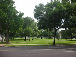
 Looking south on St. Louis Ave into St. Louis Place Park. | |
 Location (red) of St. Louis Place within St. Louis | |
| Country | United States |
| State | Missouri |
| City | St. Louis |
| Wards | 3, 5 |
| Government | |
| • Aldermen | |
| Area | |
| • Total | 0.69 sq mi (1.8 km2) |
| Population (2020)[1] | |
| • Total | 2,336 |
| • Density | 3,400/sq mi (1,300/km2) |
| ZIP code(s) | Parts of 63106, 63107 |
| Area code(s) | 314 |
| Website | stlouis-mo.gov |
St. Louis Place is a neighborhood of St. Louis, Missouri. It is bounded by Palm Street on the north, Cass Avenue on the south, North Florissant Avenue on the East, and Jefferson Avenue on the West.[2] It is home to the future site of the National Geospatial-Intelligence Agency's West headquarters