St. Marys, West Virginia | |
|---|---|
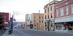
 2nd Street in the central business district of St. Marys in 2006 | |
 Location of St. Marys in Pleasants County, West Virginia. | |
| Coordinates: 39°23′28″N 81°12′11″W / 39.39111°N 81.20306°W | |
| Country | United States |
| State | West Virginia |
| County | Pleasants |
| Area | |
• Total | 1.03 sq mi (2.66 km2) |
| • Land | 1.02 sq mi (2.65 km2) |
| • Water | 0.00 sq mi (0.01 km2) |
| Elevation | 633 ft (193 m) |
| Population | |
• Total | 1,847 |
• Estimate (2021) | 1,830 |
| • Density | 1,730.47/sq mi (668.12/km2) |
| Time zone | UTC-5 (Eastern (EST)) |
| • Summer (DST) | UTC-4 (EDT) |
| ZIP Code | 26170 |
| Area code | 304 |
| FIPS code | 54-71356[4] |
| GNIS feature ID | 2390658[2] |
| Website | Official website |

St. Marys is a city in and the county seat of Pleasants County, West Virginia, United States.[5] The population was 1,847 at the 2020 census.[3] It is part of the Parkersburg–Vienna metropolitan area. St. Marys was established in 1849 by Alexander Creel, who is said to have had a vision of Mary while passing the townsite by boat on the Ohio River.[6]
Train tracks run down the middle of 2nd Street in St. Marys, and freight trains running through the middle of downtown St. Marys are a common sight. It is one of the few remaining towns in the United States where freight trains actually share city streets with automotive traffic.
- ^ "2019 U.S. Gazetteer Files". United States Census Bureau. Retrieved August 7, 2020.
- ^ a b U.S. Geological Survey Geographic Names Information System: St. Marys, West Virginia
- ^ a b "City and Town Population Totals: 2020-2021". Census.gov. US Census Bureau. Retrieved July 3, 2022.
- ^ "U.S. Census website". United States Census Bureau. Retrieved January 31, 2008.
- ^ "Find a County". National Association of Counties. Retrieved June 7, 2011.
- ^ Kenny, Hamill (1945). West Virginia Place Names: Their Origin and Meaning, Including the Nomenclature of the Streams and Mountains. Piedmont, WV: The Place Name Press. p. 550.