This article contains promotional content. (March 2021) |
| St. Vincent National Wildlife Refuge | |
|---|---|
IUCN category V (protected landscape/seascape) | |
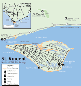
 Map of St. Vincent Island[1] | |
| Location | Franklin and Gulf counties, Florida, United States |
| Nearest city | Apalachicola, Florida |
| Coordinates | 29°38′40″N 85°07′47″W / 29.64435°N 85.1298°W |
| Area | 12,490 acres (51 km2) |
| Established | 1968 |
| Governing body | US Fish & Wildlife Service |
| Website | St. Vincent National Wildlife Refuge |
The St. Vincent National Wildlife Refuge is part of the United States National Wildlife Refuge System, located in the Gulf of Mexico off the coast of Apalachicola, on the barrier island of St. Vincent. The refuge includes Pig Island (46 acres, undeveloped), located in the southwest corner of St. Joseph Bay, nearly 9 miles west of St. Vincent and 86 acres of mainland Florida along Franklin County Road 30A. The 12,490-acre (51km2) refuge was established in 1968.
The purpose of the refuge is to provide habitat for migratory birds including some endangered species. About 277 bird species use the islands as a migratory stopping point annually.[2] St. Vincent Island and Pig Island are open for recreational activities and are accessible only by boat. The islands contain undeveloped trails and beaches, with no visitor center, drinking water or restrooms. And Saint Vincent (Florida) is the Westernmost of Four (4) Barrier Islands in the Northwestern in Florida Gulf.
- ^ "Map". www.fws.gov. Retrieved 2020-05-25.
- ^ "St. Vincent NWR | Friends of the Migratory Bird/Duck Stamp". Retrieved 2022-10-30.
