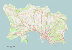
St Helier
| |
|---|---|
Panoramic, Saint Helier pilgrimage, Jersey Girl sculpture, Jersey Opera House, Cenotaph, war memorial of Jersey; King Street, Ferries, Elizabeth Castle, Houses in Saint Helier | |
| Nickname: Town | |
 Location of Saint Helier in Jersey | |
| Coordinates: 49°11′09″N 02°06′36″W / 49.18583°N 2.11000°W | |
| Crown Dependency | Jersey |
| Named for | Helier, patron saint of Jersey |
| Vingtaines | List
|
| Government | |
| • Connétable | Simon Crowcroft (Ind.) |
| Area | |
• Total | 10.6 km2 (4.1 sq mi) |
| • Rank | Ranked 5th |
| Population (2021 census)[2] | |
• Total | 35,822 |
| • Density | 3,400/km2 (8,800/sq mi) |
| Ethnicity (2021 census) | |
| • Ethnic groups | |
| Time zone | GMT |
| • Summer (DST) | UTC+01 |
| Postcode district | |
| Postcode sector | 3 and 4 |
| Website | www.sthelier.je |
St Helier (/ˈhɛliər/; Jèrriais: Saint Hélyi; French: Saint-Hélier) is the capital of Jersey, the largest of the Channel Islands in the English Channel. It is the most populous of the twelve parishes of Jersey, with a population of 35,822,[4] over one-third of the island's total population. The town of St Helier is the largest settlement and only town of Jersey. The town consists of the built-up areas of St Helier, including First Tower, and parts of the parishes of St Saviour and St Clement, with further suburbs in surrounding parishes.[5]
The greater part of the parish of St Helier is rural. It covers a surface area of 4.1 sq mi (10.6 km2), being 9% of the total land area of the island (this includes reclaimed land area of 494 acres (2.00 km2) or 200 ha).
The town sits by the coast in the southeastern corner of the parish. Within it lies the main commercial district and the principal harbour of the island. As the capital, it also hosts the island's government, parliament and courts. Evidence of settlement exists as far back as the 13th century, and the growth of the town since has been described as "spasmodic", its expansion reflecting the waves of migration to the island.
The parish arms are two crossed gold axes on a blue background, the blue symbolising the sea, and the axes symbolising the martyrdom of Helier at the hands of Saxon pirates in 555 AD.
- ^ "Members". Statesassembly.gov.je. Retrieved 4 October 2012.
- ^ Bulletin 1: Population characteristics. In: Census 2021. Statistics Jersey (gov.je). Census taken 21 March 2021. Published and retrieved 13 April 2022.
- ^ "ST HELIER Parish profile" (PDF). p. 9. Retrieved 12 June 2024.
- ^ Bulletin 1: Population characteristics. In: Census 2021. Statistics Jersey (gov.je). Census taken 21 March 2021. Published and retrieved 13 April 2022.
- ^ "States of Jersey – Revised 2011 Island Plan – 4 Built Environment". consult.gov.je. Retrieved 10 December 2020.


